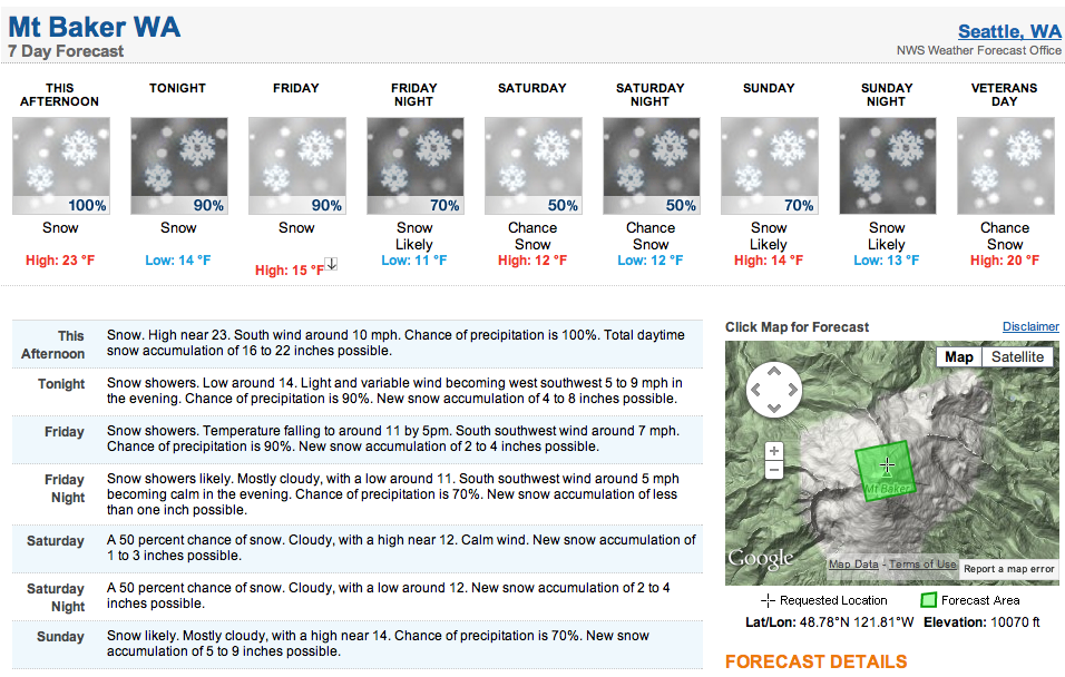
Up to 50 inches of snow is forecasted in the next 4 days on the summit of 10,781-foot Mt. Baker in Washington state. The forecasted snow levels will begin at 5,000 feet with this storm, so the most impressive snowfall totals are going to be above the mountain passes. Snow levels will drop to mountain pass levels (about 3,000 feet) by tomorrow morning and this is when places like Mt. Baker ski resort will start seeing snow as well.
Mt. Baker ski resort could see up to 8” from this storm.
The Mt. Baker area of Washington is one of the snowiest places on Earth. It’s only real rival is Japan. So far this year, Mt. Baker is living up to it’s name. The 13-foot storm on Mt. Baker in September definitely helped get the ball rolling.

We’re hoping to have another solid backcountry conditions report from the Glacier Ski Shop crew after the storm drops its snow. Their video skiing Mt. Baker yesterday makes it look like the coverage is in above 5,500-feet.
RELATED POSTS:
Mt. Baker, WA Conditions Report Video: 30” of Pow Yesterday
The Top 10 Snowiest Ski Resorts in North America:
One thought on “50” of Snow Forecasted on Mt. Baker, WA in Next 4 Days”