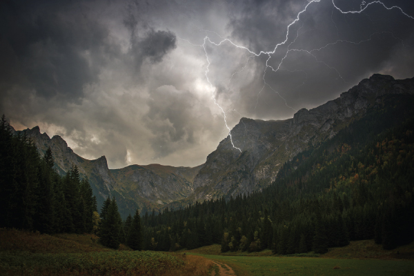
Thunderstorms can be a nearly daily staple in the mountains in the summertime, and understanding how they form can help prevent dangerous situations associated with them.
The key theory behind thunderstorm formation is instability. The state of being stable can be described as something lacking the “desire” or mechanism to change states. There are two things that can cause or force atmospheric instability and trigger thunderstorms: buoyant instability and vertical forcing.
Let’s talk about buoyant instability first. If an air parcel (a “bubble” of air) is warmer than its surroundings, it will ascend, as warm air is less dense than cool air. As long as the parcel’s surroundings remain colder than it, it will continue to rise. Rising air is the secret to all thunderstorm formations.
However, as the parcel rises into colder and colder environments, it will naturally cool down. This is where meteorologists use a tool known as a parcel lapse rate. A parcel lapse rate assesses the rate at which air parcels will cool down in any given atmospheric environment. The average lapse rate is 6.5ºC/1,000ft.
Let’s think of an example to aid our understanding of lapse rates and thunderstorms. Say you have two different atmospheres; one with a very steep temperature gradient and one with a mellow temperature gradient. The mellow temperature gradient has a surface temperature of 30ºC, and the temperature at 5,000 feet is 0ºC. In this atmosphere, say the lapse rate is 6.5ºC/1000ft. If the air parcel starts ascending at surface level at 30ºC, it would theoretically cool to 23.5ºC at 1000ft in the atmosphere. However, the ambient air temperature at 1,000 would be 24ºC (30ºC/5). Hence, the vertical velocity of our bubble of rising air would be arrested, as its density is lower than its surroundings.
In the steep temperature gradient environment, say our surface temperature is 30ºC but the temperature at 5,000 feet is -30ºC. If our parcel starts at 30ºC with a lapse rate of 6.5ºC/1,000ft, our air parcel is 23.5ºC at 1,000 feet, but the surrounding environment is 18ºC! Thus, at 1,000 feet, the air continues to rise. At 2,000 feet, our air parcel is now 17ºC, but the surrounding environment is 6ºC, hence it continues to rise. This will continue to go on and on, the parcel continuing to rise, so long as the external temperature is lower than the parcel temperature.
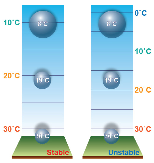
From these examples, it becomes clear that the mechanism behind atmospheric instability is sharp temperature gradients throughout vertical profiles in the atmosphere. This can be achieved by particularly warm surface temperatures (which can occur when the sun heats the ground, which is why so many thunderstorms occur in the summer on hot, sunny days), or when the upper levels of the atmosphere are particularly cold.
As the air cools as it rises, the temperature of the parcel nears the dew point, thus causing humidity to rise, moisture to condense, and precipitation to fall. Additionally, the upward velocity of the air smashes dust, water, and other particles into each other, generating electric charge, and when enough charge is built up, thunder and lightning may occur.
The second way that thunderstorms can form is by vertical forcing. Vertical forcing requires active ascent rather than passive ascent (buoyant instability). One simple way that vertical forcing can occur is if wind is blowing perpendicular to mountains, which causes the air to ascend their slopes and then continue upwards once they pass the peaks. If the wind is strong enough, it can blow an air parcel up to the point where passive vertical ascent can occur if the temperature gradient is right. Think of vertical forcing as a kick start to positive buoyancy.
The second example of active vertical forcing is cold fronts. Cold air is denser than warm air, so as a cold front intrudes into a warmer environment, it will “burrow” underneath the warmer air, which gives it the vertical velocity to rise quite quickly and produce violent precipitation and thunderstorms.

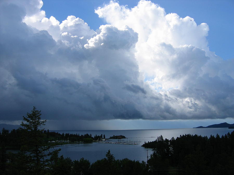
Knowing some early warning signs of thunderstorms is very important to staying safe. Strong winds, hail, and lightning all pose risks to our well-being, so understanding how to avoid them before it’s too late is crucial. The first thing you should always do is check the forecast. If afternoon thunderstorms are forecasted, make a plan to get yourself in a safe environment in the early afternoon. A visual sign that you can check for while out in the environment is tall, puffy clouds. If a cloud is particularly tall, it indicates that there is significant vertical ascent occurring and can give way to powerful thunderstorms in a matter of minutes!