California is currently battling several wildfires, including at least one major, widespread wildfire. Governor Jerry Brown declared a state of emergency due to the spreading Pawnee Fire, while other smaller blazes burned throughout the state.
Here is where the Pawnee Wildfire and other major fires are burning this week in California:

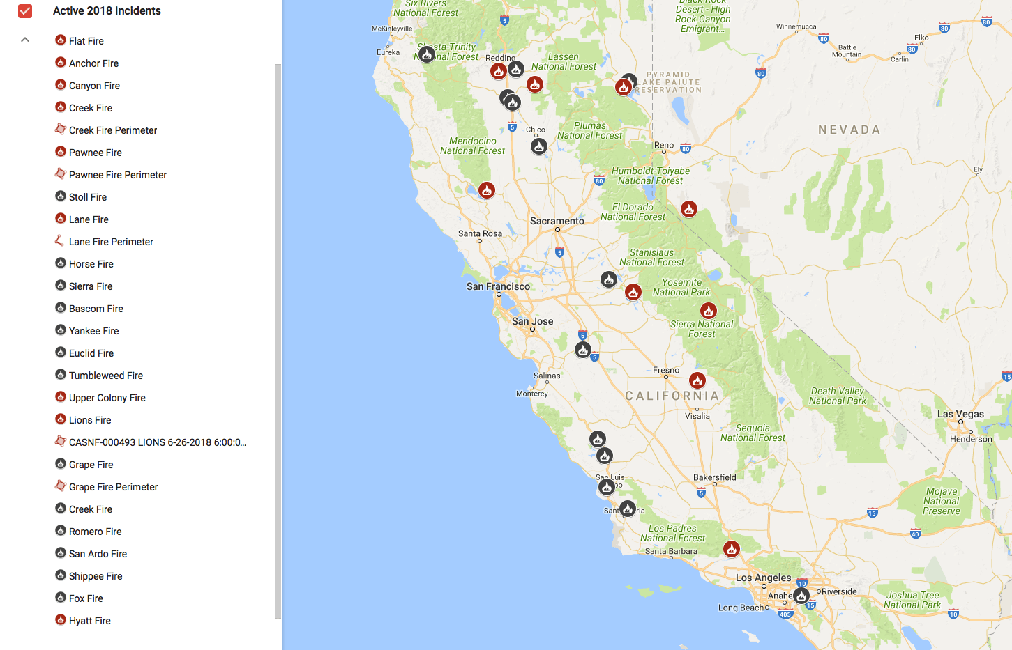
Pawnee Fire, Lake County: 13,700 acres, 30 percent contained
The Pawnee Fire in Lake County, California, grew to 13,700 acres by Thursday morning, the California Department of Forestry and Fire Protection confirmed. The fire is threatening hundreds of homes and has already destroyed an estimated 22 structures.
The fire was 30 percent contained Thursday, and almost 3,000 fire personnel were at the scene working toward full containment. Multiple fire departments were making use of some 15 helicopters, hundreds of fire engines and other aircraft.
Mandatory evacuation orders remained in place for the Spring Valley community, while pre-evacuation notices were issued for other nearby areas, Cal Fire said. Evacuation orders were also issued for homes in Double Eagle Ranch due to “significant fire activity” nearby, KABC-TV reported.
Residents near the Pawnee Fire were asked to conserve water in an effort to help firefighters working to combat the flames. Evacuation sites were set up at Moose Lodge and Lower Lake High School. Officials said the fire’s spread was being driven by “erratic winds,” low humidity and above normal temperatures. The cause remained unclear.

Lane Fire, Tehama County: 3,829 acres, 75 percent contained
California fire officials worked toward full containment on the Lane Fire in Tehama County Wednesday. The almost 4,000-acre fire, burning off Highway 36 in Payne’s Creek, was about 75 percent contained. The fire was not threatening any structures. A little more than 1,000 firefighters were on scene doing “aggressive work,” Cal Fire said.
Evacuation warnings previously in place for homes in Ponderosa Sky Ranch and Payne’s Creek were lifted.

Lions Fire, Ansel Adams Wilderness: 3,002 acres
The Lions Fire burning in California’s Ansel Adams Wilderness grew to almost 3,000 acres by Wednesday. The fire was ignited by a lightning strike June 11 and was burning about seven miles southwest of Mammoth Lakes. Lodging and recreational areas, as well as trails like the Pacific Crest Trail and the John Muir Trail, remained open. Some 266 firefighters were at the scene. Smoke from the Lions Fire continues to impact the Central Sierra
The fire was expected to be fully contained by about July 14.

Creek Fire, Shasta County: 1,475 acres, 70 percent contained
The Creek Fire in Shasta County was about 70 percent contained Thursday. The flames destroyed four homes and seven other structures. An emergency declaration for the county was issued Monday by Sheriff Tom Bosenko as a result of the fire.
At least one person was injured in the fire, Cal Fire’s Shasta-Trinity Unit said. It was unclear if that person was a firefighter or what the extent of their injuries was. Some residents that were previously evacuated by the wildfire were allowed to return home Tuesday evening.
The cause of the fire was under investigation, though it was considered “suspicious,” according to the Redding Record Searchlight.

Stoll Fire, Tehama County: 268 acres, 100 percent contained
The Stoll Fire, burning near Stoll Road and Baker Road west of Red Bluff in Tehama County, is now fully contained Thursday. While the fire was smaller than others burning in California this week, it destroyed four homes, 10 commercial buildings and 10 outbuildings.
Crews said forward spread of the fire was stopped and that good progress was being made. Some residents who were previously evacuated were allowed to return home. The cause of the fire was under investigation.
Red Flag Warnings & Fire Weather Watches
The National Weather Service issues Red Flag Warnings & Fire Weather Watches to alert fire departments of the onset, or possible onset, of critical weather and dry conditions that could lead to rapid or dramatic increases in wildfire activity.

A Red Flag Warning is issued for weather events which may result in extreme fire behavior that will occur within 24 hours. A Fire Weather Watch is issued when weather conditions could exist in the next 12-72 hours. A Red Flag Warning is the highest alert. During these times extreme caution is urged by all residents because a simple spark can cause a major wildfire. A Fire Weather Watch is one level below a warning, but fire danger is still high.
The type of weather patterns that can cause a watch or warning include low relative humidity, strong winds, dry fuels, the possibility of dry lightning strikes, or any combination of the above.
During heightened fire danger, CAL FIRE will place additional firefighters on duty, staff more fire engines and keep more equipment on 24 hours a day to be able to respond to any new fires. CAL FIRE urges Californians to be extremely cautious, especially during periods of high fire danger. It’s important all residents and visitors take steps to prevent wildfires.
One less spark could mean one less wildfire.