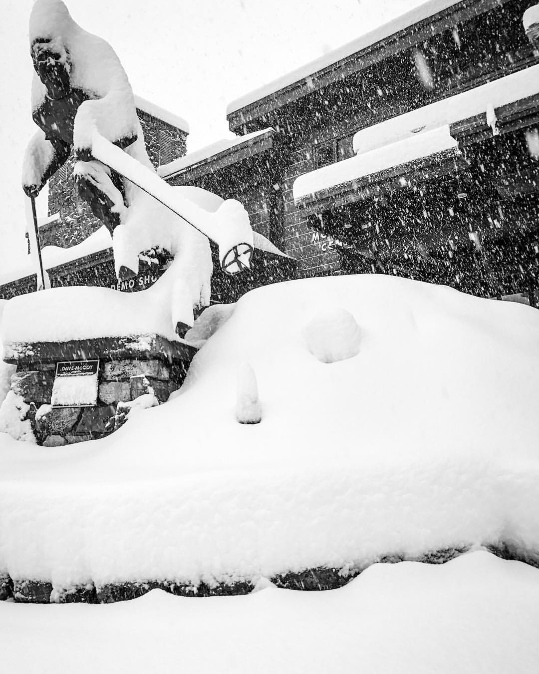
The Atmospheric River Event has begun and it isn’t disappointing. It dropped over 1 FOOT of snow on multiple California resort already. An Avalanche Warning has been issued for the Tahoe area as heavy snowfall will create unstable snow conditions.
2-4 FEET of snow is forecasted to fall Today-Tomorrow above 7500ft.
24 Hour Snowfall Totals As of This Morning:
Mammoth Mountain: 20″
Mt. Shasta Ski Park: 17″
Sugar Bowl: 16″
Northstar Resort: 13″
Kirkwood Resort: 12″
Squaw Valley: 12″
Ski China Peak: 12″
Homewood Mountain Resort: 9″
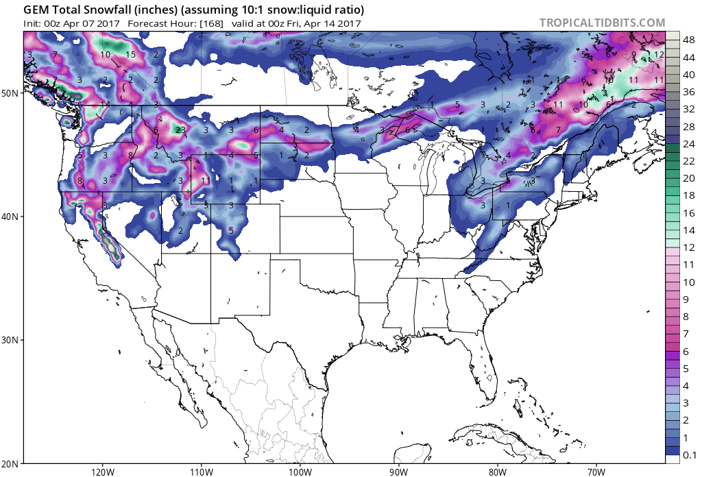
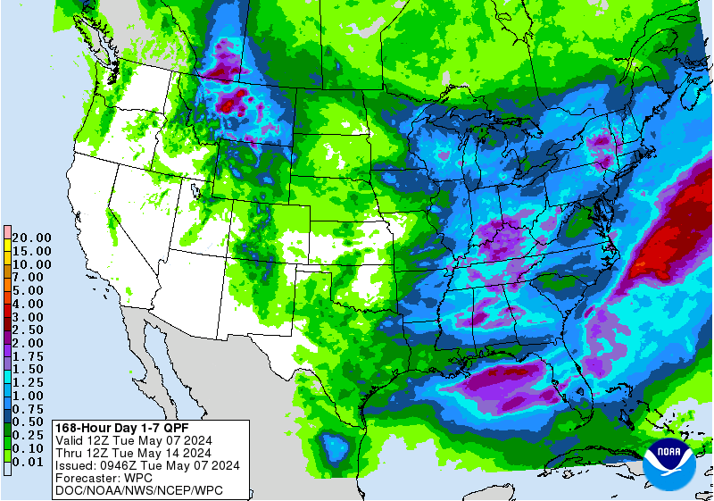
48+” of snow in the 7 day forecast for California. Image: Tropical Tidbits7 day precipitation total. Image: NOAA
Snow levels are expected to start out around 6500-7000ft today, before dropping to 4500ft by Saturday morning.
Additional Storm Information:
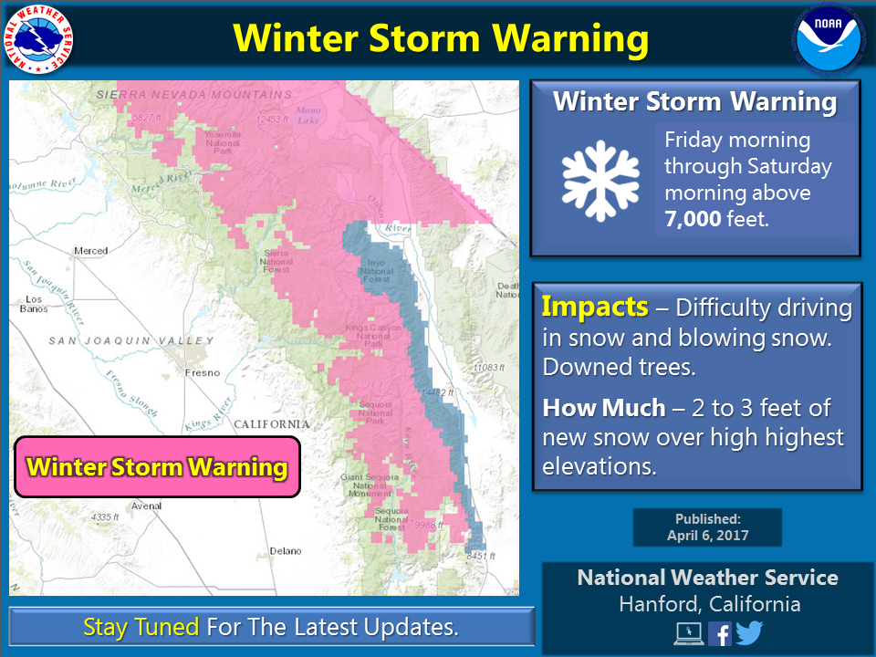
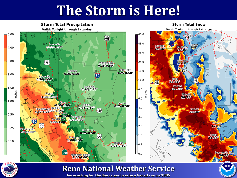
“A winter storm warning is in effect from Friday morning through Saturday morning for the Sierra Nevada from the Kern/Tulare County line north to Yosemite National Park above 7,000 feet. ” – NOAA Hanford, CA“The Storm Is Here! Heavy rain, snow, and strong winds will impact the Sierra and western Nevada through Saturday.” – NOAA Reno, NV
California: 2-4 FEET of Snow Today-Tomorrow Above 7500ft
* Snow Accumulations: 2 to 4 feet of snow above 7500 feet
  elevation. 6 to 12 inches around Lake Tahoe level, including
  Truckee and South Lake Tahoe with the potential for up to 18
  inches if snow levels drop sooner than currently expected.
- NOAA Reno, NV
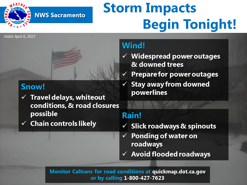
“Storm impacts will begin tonight. Widespread power outages & downed trees, hazardous weather conditions, and travel delays are all possible with this storm.” – NOAA Sacramento, CA Yesterday
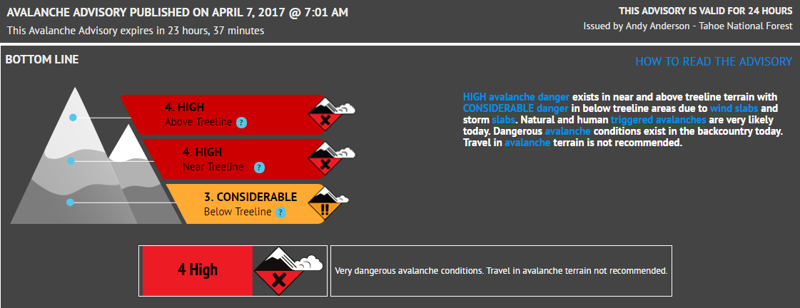
“HIGH avalanche danger exists in near and above treel ine terrain with CONSIDERABLE danger in below tree line areas due to wind slabs and storm slabs. Natural and human triggered avalanches are very likely today.” – NOAA Reno, NV Today
Tahoe Area Avalanche Warning:
URGENT - IMMEDIATE BROADCAST REQUESTED
Avalanche Warning
Forest Service Sierra Avalanche Center
Relayed by National Weather Service Reno NV
744 AM PDT Fri Apr 7 2017

The following message is transmitted at the request of the Forest
Service Sierra Avalanche Center.

The Forest Service Sierra Avalanche Center has issued a
backcountry Avalanche Warning.

* Timing...in effect from 7 am Friday through 7 am Saturday.

* Affected Area...for the Sierra Nevada Mountains of California
  and Nevada, from Yuba Pass to Ebbetts Pass, including the Lake
  Tahoe Basin.

* Avalanche Danger...High.

* Reason/Impacts...HIGH avalanche danger may exist in near and
  above treeline terrain with CONSIDERABLE danger in below
  treeline areas due to wind slabs and storm slabs. Natural and
  human triggered avalanches are very likely today. Dangerous
  avalanche conditions exist in the backcountry today. Travel in
  avalanche terrain is not recommended.

* Uncertainty...Due to uncertainty concerning snowfall amounts the
  avalanche hazards could vary greatly from place to place. In
  areas that receive the high end of forecasted snow amounts, more
  avalanche danger and larger avalanche problems will exist. In
  areas where snow totals only reach the low end of the forecasted
  accumulation, the avalanche problems could be smaller and less
  widespread.
6-10 day temperature outlook. Image: NOAA6-10 day precipitation outlook. Image: NOAA
Winter Storm Warning:
URGENT - WINTER WEATHER MESSAGE
National Weather Service Reno NV
317 AM PDT Fri Apr 7 2017
Greater Lake Tahoe Area-
Including the cities of South Lake Tahoe, Truckee, Stateline,
and Incline Village
317 AM PDT Fri Apr 7 2017
...WINTER STORM WARNING REMAINS IN EFFECT UNTIL 5 PM PDTSATURDAY...
* Timing: Heavy wet snow will spread to lake level by tonight
through Saturday. Snow should taper to showers on Saturday.
* Snow Levels: Snow levels starting 6500-7000 feet today, falling
to 4500 feet by Saturday morning. Snow levels may fluctuate
around Lake Tahoe level during the day today.
* Snow Accumulations: 2 to 4 feet of snow above 7500 feet
elevation. 6 to 12 inches around Lake Tahoe level, including
Truckee and South Lake Tahoe with the potential for up to 18 inches if snow levels drop sooner than currently expected.
* Winds: Strong southwest winds area wide, with gusts Thursday
night through Saturday morning ranging from 45-55 mph along I-80
and near Lake Tahoe, and up to 135 mph along the higher mountain peaks and ridges.
* Impacts: Significant travel disruptions today at pass elevations
including Donner, Echo, Spooner, and Mount Rose summits. Travel
disruptions affecting mountain communities through Saturday
including around Lake Tahoe. Heavy wet snow and strong winds could lead to downed trees and power outages.