According to the NASA Earth Observatory, Ecuador’s tallest waterfall has mysteriously vanished, puzzling researchers. According to local authorities, a sinkhole recently formed a few feet above the San Rafael Waterfall which may have redirected its water flow. NASA is investigating the waterfall’s disappearance and they wrote on their website,
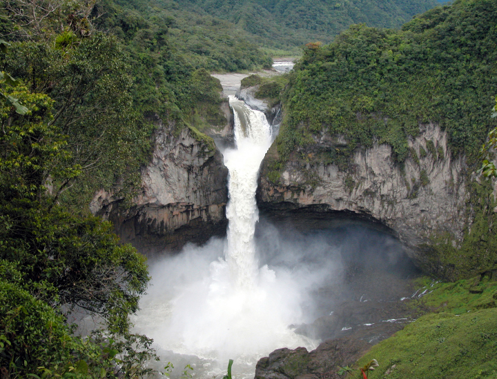
Surrounded by lush vegetation and rare butterflies, the San Rafael Waterfall was one of the most captivating landscapes in Ecuador. With water dropping 150 meters (490 feet), the river and falls cut through a thick patch of cloud forest at the intersection of the Andes Mountains and the Amazon Basin. As the country’s tallest waterfall, it attracted tens of thousands of visitors per year.
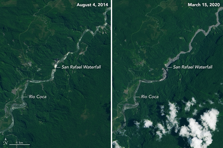
But now, the cascade has disappeared. It stopped flowing on February 2, 2020. The images above show the falls and the surrounding river basin while water still flowed on August 4, 2014 (left) and after it stopped on March 15, 2020 (right). These images were acquired by the Operational Land Imager (OLI) on Landsat 8. The image below shows a photograph of the falls on November 28, 2012.
According to media reports, a huge sinkhole appeared in the Coca River a few meters before the falls and diverted the watercourse. Now, the water falls in three separate sections and at a less steep slope, which cannot be seen from viewing stations located around the original waterfall. Researchers believe the three streams could cause erosion at the channel’s origin and create a river upstream, which might change the topography of the valley.
The cause of the sinkhole is under investigation. Some geologists think the deformation occurred naturally, while other researchers suspect it may be tied to the new construction of the country’s largest hydroelectric plant. No matter the cause, Ecuador’s tourism ministry does not plan to reconstruct the riverbed or restore San Rafael. The waterfall is now part of history.
NASA Earth Observatory image by Lauren Dauphin, using Landsat data from the U.S. Geological Survey. Photograph courtesy of Ecuador Ministry of Tourism via CC BY-SA 2.0. Story by Kasha Patel.