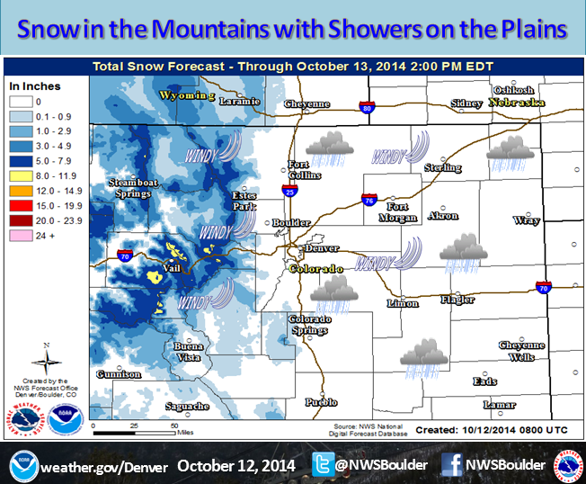
NOAA is currently forecasting up to 10″ of new snow in Colorado today. NOAA has issued 6 different Winter Weather Advisories in Coloroado that will remain in effect all day until midnight tonight.
Loveland and Arapahoe Basin ski resorts are currently racing to become the first ski resorts to open in the USA this season. This storm is likely going to give them the boost to pull it off very soon. Last year, Arapahoe Basin opened on October 13th, 2014. If everything goes right, Coloradans could be skiing as soon as this week.

NOAA Denver:
Rain and snow showers will increase over the higher terrain this morning and continue through this evening with 4 to 8 inches of snow above 10000 feet. Northwest winds of 15 to 25 mph with gusts to 40 mph will produce areas of blowing snow as well.
Over northeast Colorado a cold front will move across the area by midday with north winds of 20 to 30 mph developing. Some gusts up to 40 mph will occur as well. Rain showers along with a few thunderstorms will also develop by midday and continue through the afternoon before gradually ending by early evening. Temperatures may become cold enough for some light snow over the Palmer Divide early this evening before the precipitation ends. – NOAA Denver, CO
NOAA’s Winter Storm Advisory:
URGENT - WINTER WEATHER MESSAGE
NATIONAL WEATHER SERVICE DENVER/BOULDER CO
356 AM MDT SUN OCT 12 2014

...A FAST BUT POTENT STORM SYSTEM WILL AFFECT THE NORTH CENTRAL
MOUNTAINS TODAY...

A STORM SYSTEM MOVE QUICKLY ACROSS COLORADO TODAY. BRIEF PERIODS
OF HEAVY SNOW COUPLED WITH STRONG WINDS WILL CAUSE ROADS TO BECOME
ICY AND SNOW PACKED OVER THE HIGH MOUNTAIN PASSES. PEOPLE PLANNING
TRAVEL IN THE COLORADO MOUNTAINS SHOULD BE PREPARED FOR WINTRY
DRIVING CONDITIONS LATER THIS MORNING AND CONTINUING THROUGH
THIS EVENING.

...WINTER WEATHER ADVISORY REMAINS IN EFFECT FROM 9 AM THIS
MORNING TO MIDNIGHT MDT TONIGHT...

* TIMING...SNOW WILL DEVELOP THIS MORNING...AND BECOME HEAVY AT
  TIMES. INITIALLY...SOME RAIN CAN BE EXPECTED IN VALLEY
  LOCATIONS. THE SNOW IS EXPECTED TO DECREASE IN INTENSITY THIS
  EVENING.

* SNOW ACCUMULATIONS...STORM TOTALS OF 4 TO 10 INCHES.

* WIND/VISIBILITY...NORTHWEST WINDS 20 TO 35 MPH WITH GUSTS TO 50
  MPH ABOVE TIMBERLINE. AREAS OF BLOWING SNOW WILL REDUCE
  VISIBILITIES TO LESS THAN A QUARTER MILE AT TIMES.

* IMPACTS...WINTER DRIVING CONDITIONS WITH SNOWPACKED ROAD
  SURFACES AND POOR VISIBILITY WILL DEVELOP TODAY AND CONTINUE
  THROUGH THIS EVENING.

PRECAUTIONARY/PREPAREDNESS ACTIONS...

A WINTER WEATHER ADVISORY FOR SNOW MEANS THAT PERIODS OF SNOW AND
BLOWING SNOW WILL CAUSE PRIMARILY TRAVEL DIFFICULTIES. BE
PREPARED FOR SNOW COVERED ROADS AND LIMITED VISIBILITIES...AND
USE CAUTION WHILE DRIVING.
One thought on “NOAA: 10″ of Snow TODAY in Colorado”