Last week the NOAA released its outlook for April 2024. Here’s a AI simplified summary of the forecast discussion, focusing on skiers and regions where snow is likely:
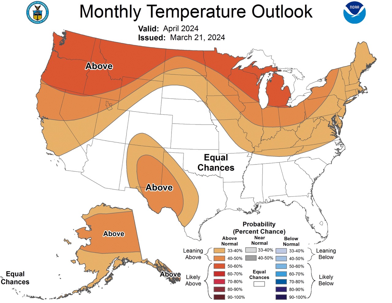
Temperature Outlook:
- Elevated chances for above-normal temperatures in many regions.
- West Coast states eastward to the Northern Plains and southeastward across the Upper and Middle Mississippi Valley, Great Lakes, Ohio Valley, and parts of the Appalachians and Atlantic coastal plain are likely to experience above-normal temperatures.
- Factors such as Final Consolidation tool, Constructed Analog on Soil Moisture Tool, and El Nino impacts contribute to this forecast.
- Parts of the Far West, Four Corners states, southern Texas, Mid-Atlantic, and Northeast coastal areas may also experience relative warmth.
- Southern Rockies and southern High Plains are expected to have increased chances for above-normal temperatures due to dry soils and high sun-angle.
- Alaska, except for the Aleutians, may experience above-normal temperatures.
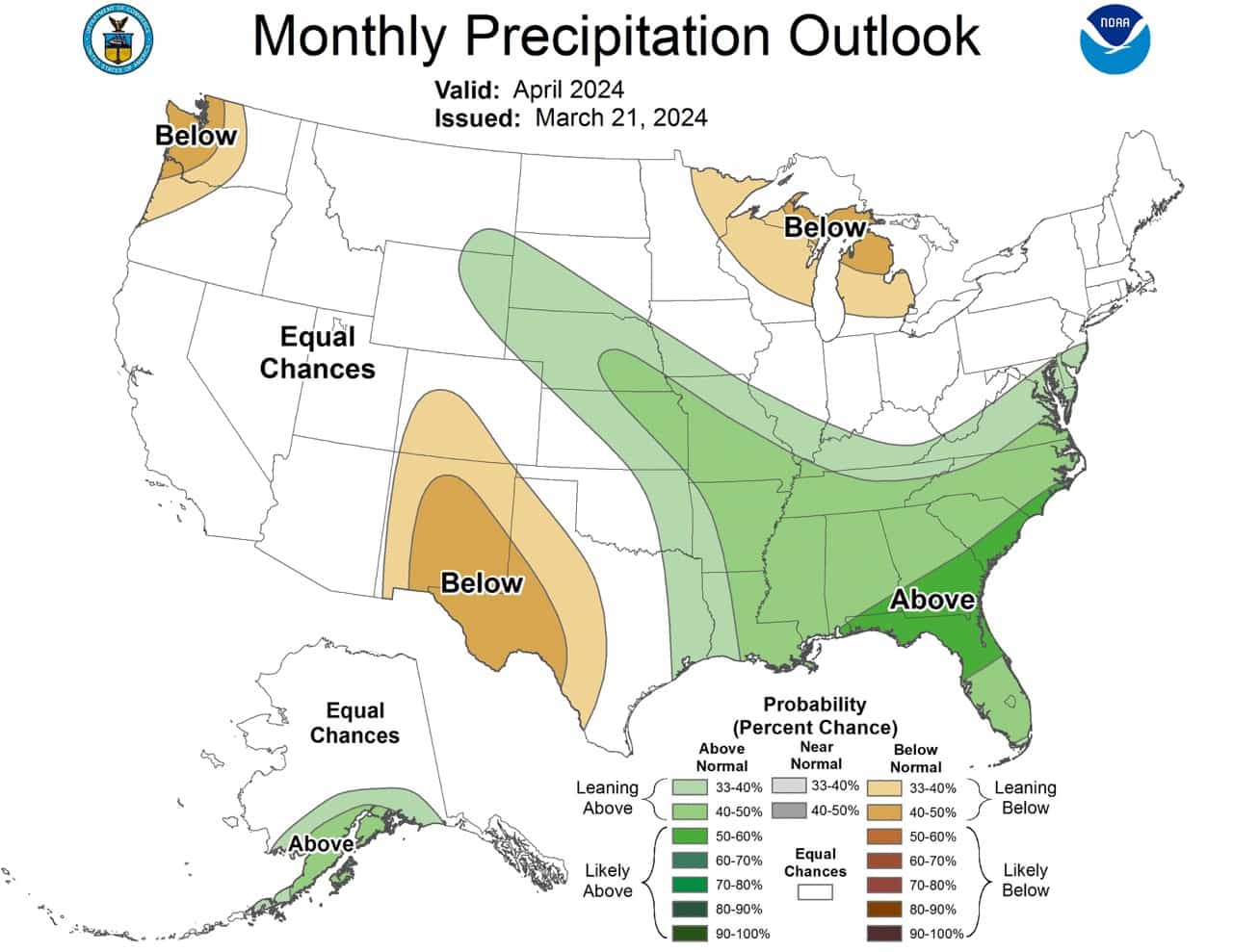
Precipitation Outlook:
- Wetter-than-normal conditions are favored from the southeastern CONUS northwestward into the north-central High Plains.
- Below-normal precipitation is expected for the Upper Great Lakes region due to low snow depth, low soil moisture, and El Nino impacts.
- Southwest Colorado, New Mexico, and most of West Texas may experience below-normal precipitation due to low soil moisture and high sun-angle.
- Parts of the Northwest may also see below-normal precipitation.
- In Alaska, there are differences in forecasts, but there’s an elevated chance of above-normal precipitation across the southern part, including the Alaska Peninsula.
What Does That Mean for Skiers?
- Skiers in the West Coast states, Northern Plains, and parts of the Midwest should expect above-normal temperatures, potentially affecting snow conditions.
- The North-Central High Plains may see wetter-than-normal conditions, which could benefit ski resorts in those areas.
- Skiers in the Upper Great Lakes region may experience below-normal precipitation, potentially impacting snowpack and skiing conditions negatively.
- Southwest Colorado, New Mexico, and West Texas may also see below-normal precipitation, affecting ski areas in those regions.
- Skiers in Alaska, particularly the southern part, may experience above-normal precipitation, which could enhance skiing opportunities in those areas.
Here is the full NOAA discussion:
30-DAY OUTLOOK DISCUSSION FOR APRIL 2024

The April 2024 monthly temperature and precipitation outlooks are based on
various climate factors (such as ENSO and to some degree, the Madden-Julian
Oscillation (MJO)), boundary conditions (snow depth and soil moisture),
dynamical and statistical model guidance, and historical temperature and
precipitation trends .

Sea-surface temperature (SST) anomalies across the central and eastern
equatorial Pacific have significantly decreased during the past few weeks, and
a relatively small extent of anomalously cool water has appeared over the
eastern Pacific related to the upwelling phase of an oceanic Kelvin wave.
Cooler-than-average subsurface temperatures have developed over much of the
eastern Pacific. By mid-March, enhanced trade winds have returned to a large
portion of the equatorial Pacific. All these factors are consistent with a
rapidly weakening El Nino, which has been in place for just over one year. El
Nino is forecast to transition to ENSO-neutral during the April-May-June (AMJ)
season. However, El Nino impacts are expected to linger well into the month of
April across the United States, and these expected impacts were considered in
the construction of the April outlook. Another climate factor to consider is
the currently robust MJO. The enhanced convective phase of the MJO is located
over the Western Pacific (Phase 7 in RMM space), and the suppressed phase of
the MJO is located over the Indian Ocean (Phases 2 and 3 in RMM space). Model
forecasts of the MJO index propagate the MJO signal into the Western Hemisphere
over the next two weeks. Within the first week of April, lagged MJO composites
for Phase 7 favor anomalously cool temperatures over at least the central third
of the contiguous U.S. (CONUS).

In addition to the climate factors noted above, there is an extensive area of
anomalously low snow depth from Montana eastward across the Northern Great
Plains, Great Lakes region, and Northeast. From eastern Montana across the
Northern Plains snow depth departures are generally 8 inches or less, though in
the vicinity of Great Falls, Montana, snow depth departures range from 2-3 feet
(locally greater) below normal. From the Upper Mississippi Valley eastward
across the Great Lakes and New England snow depth ranges anywhere from 8-30
inches below normal.  Unusually low snow depth means less water will be
available for staggered release into soils during the beginning weeks of the
growing season. Much of this region is also experiencing relatively low soil
moisture values. The exception is the Northeast, where recent precipitation has
resulted in ranked soil moisture percentiles in excess of the 95th percentile.

For the April temperature outlook, there are elevated chances for above-normal
temperatures from most of the West Coast states eastward and northeastward into
the Northern Plains, continuing eastward and now southeastward across the Upper
and Middle Mississippi Valley, Great Lakes region, Ohio Valley and neighboring
portions of Tennessee, most of the Appalachians, and the Atlantic coastal plain
from Maine to northern North Carolina. The favored above-normal temperatures
are generally supported by the Final Consolidation tool (Final-CON) which
skill-weights a consolidation of dynamical models  (NMME-CON) and a
consolidation of statistical models (Stat-CON). These temperatures are also
generally supported by the Constructed Analog on Soil Moisture Tool (CA-SMT),
and to a lesser degree the International Multi-Model Ensemble (IMME, also
referred to as C3S or Copernicus), CFS, calibrated NMME (PAC), and GFDL SPEAR
models. Most of the favored above-normal temperatures were derived from
dynamical model guidance rather than statistical model guidance. Expected
lagged El Nino impacts also played a role in this forecast, as well as
above-normal SSTs along the West Coast. The boundary conditions noted earlier
played a significant role in the temperature forecast from Montana eastward
across the Great Lakes and Northeast. The probabilities favoring above-normal
temperatures across New England and eastern New York state were tempered by
anomalously high soil moisture values. The 15-year Optimal Climate Normals
(OCN) temperature tool, a proxy to the last 15 years of historical temperature
trends, favored relative warmth across portions of the Far West, Four Corners
states, southern Texas, and the Mid-Atlantic and Northeast coastal plain. There
are increased chances for above-normal temperatures over the southern Rockies
and southern High Plains, associated with anomalously dry soils, the three CON
tools (noted above), and a high sun-angle. Most model guidance supported
above-normal temperature chances for most of Alaska, with the exception of the
Aleutians where Equal Chances (EC) of below, near, and above-normal monthly
mean temperatures are favored.

The April precipitation outlook is based on the same climate factors, boundary
conditions, and model guidance as the April temperature outlook.
Wetter-than-normal conditions are favored from approximately the southeastern
quadrant of the CONUS northwestward into the north-central High Plains. This is
generally consistent with the Final and NMME CONs, uncalibrated NMME, IMME,
historical precipitation trends , and lagged El Nino impacts. Well below-normal
snow depth, anomalously low soil moisture, and expected lagged El Nino impacts
favor below-normal precipitation for the Upper Great Lakes region. Anomalously
low soil moisture, high sun-angle, and guidance from the Final and Stat CONs
favor below-normal precipitation across southwestern Colorado, New Mexico, and
most of West Texas.  Below -normal precipitation is also favored for parts of
the Northwest, based on model support and lagged El Nino impacts. In Alaska,
there were significant differences in the precipitation forecasts, though the
IMME, GFDL SPEAR, and Canadian CanCM4i models supported an elevated chance of
above-normal precipitation across the southern part of the state, including the
Alaska Peninsula.