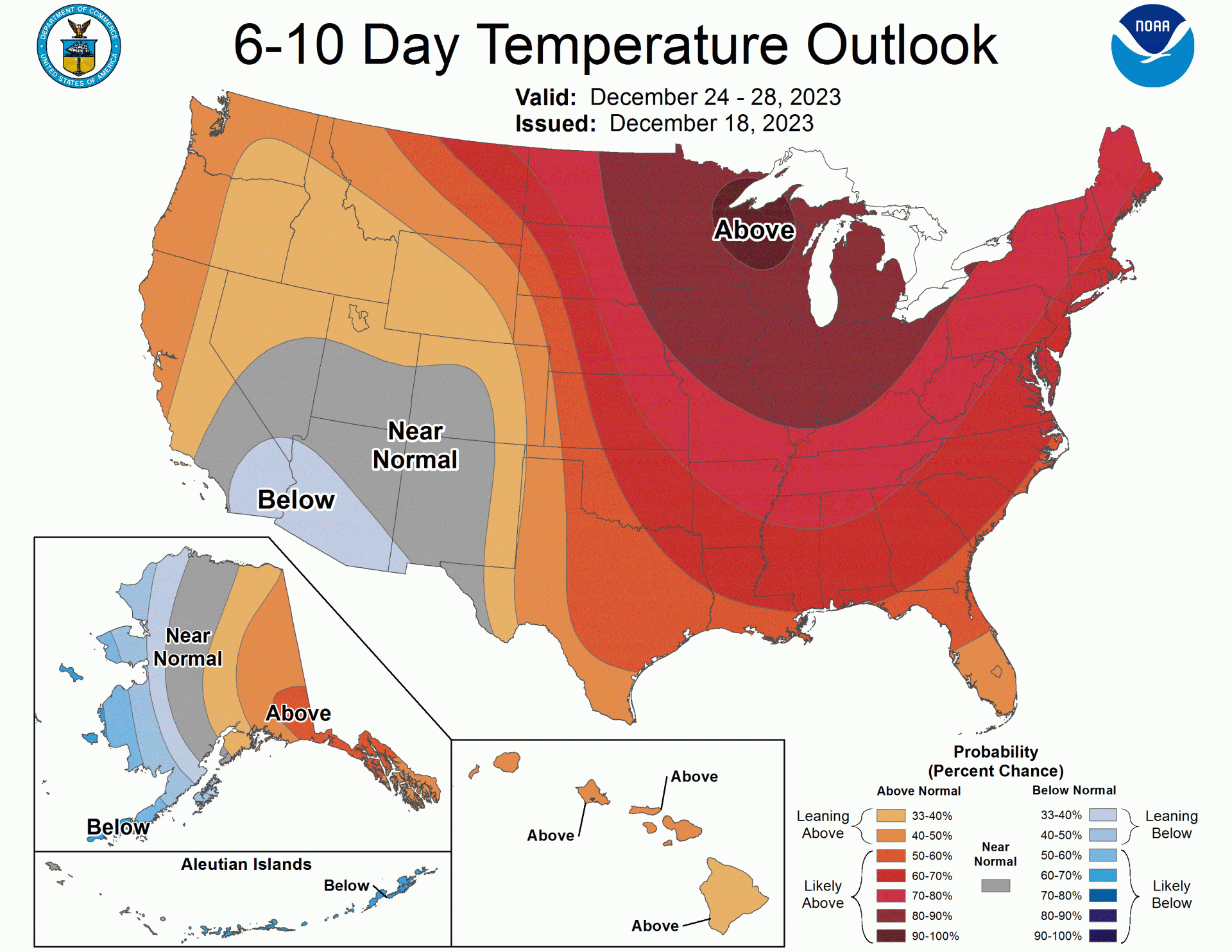
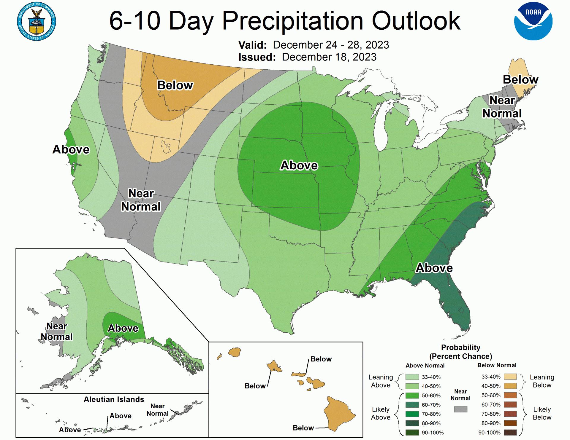
Yesterday, the NOAA released a 6-10 day outlook covering the Christmas period. Most of the US will stay warmer than normal due to the Pacific airflow. Expect more rain or snow than usual in the Pacific Northwest, California, western Nevada, and Alaska. There’s a good chance for rain along the entire East Coast, too, especially in the Southeast. It will be drier than usual in parts of the Northwest and the Northern Rockies.
Here’s the discussion, simplified by AI for those unfamiliar with meteorological jargon:
1. General Forecast Overview:
- Weather models are mostly in agreement for the upcoming 6-10 days.
- A significant weather pattern (deep mid-level trough) is expected over the eastern Pacific Ocean, the Bering Sea, and Alaska.
2. Specific Regions and Predictions:
- Eastern Pacific, Bering Sea, Alaska: A deep weather system will affect these areas.
- Arctic Ocean: Part of this system will extend across much of the Arctic Ocean.
- Canada and Northern/Eastern U.S. (CONUS): High atmospheric pressures are predicted, which usually means calmer weather.
- Ontario and Western Quebec: Particularly high atmospheric pressures expected.
- Southwestern U.S. to Lower Mississippi Valley: Models show some uncertainty with the timing of the weather systems here.
- Hawaiian Islands: Higher than normal atmospheric heights are predicted, suggesting stable weather.
3. Temperature Forecasts:
- Continental U.S. (CONUS): Mild temperatures are expected to continue for most parts.
- Upper Great Lakes Region: Very high chances of temperatures being much warmer than usual.
- Southwest U.S.: Slightly cooler temperatures are expected following the weather system.
- Eastern Alaska: Warmer temperatures are expected due to warm air coming from the Pacific.
- Western Alaska: Cooler temperatures are likely closer to the weather system.
- Hawaii: Warmer temperatures are predicted for the entire region.
4. Precipitation Forecasts:
- Pacific Northwest, California, Western Nevada: Higher chances of more precipitation than usual due to the weather system in the Pacific.
- Interior Northwestern U.S.: Lower chances of precipitation.
- Southeast Coast of the U.S.: Significantly higher chances of more precipitation than usual.
- Maine: Slightly higher chances of less precipitation.
- Alaska: Higher chances of more precipitation.
- Hawaiian Islands: Lower chances of precipitation.
5. Forecast Confidence:
- Confidence in the 6-10 day forecast is above average (4 out of 5). This is because the models agree on the general weather patterns, but there are some differences in the precipitation forecasts.
Below is the full discussion from the NOAA:
Today’s 6-10 day dynamical model height forecasts are in fairly good agreement
across the forecast domain. A very deep mid-level trough is predicted over the
eastern Pacific, Bering Sea, and Alaska, with one lobe of this trough forecast
across most of the Arctic Ocean. The manual height blend depicts 500-hPa height
departures in excess of -240 meters over the eastern Pacific, centered in the
general vicinity of 45N-50N/150W. In contrast, large positive 500-hPa height
departures are forecast from most of Canada across a large portion of the
northern and eastern CONUS, with predicted heights in excess of +210 meters
over Ontario and western Quebec. As is often the case, the dynamical models
have difficulty timing individual mid-level troughs progressing through the
southern stream, and today is no exception with solutions predicting a 5-day
mean trough from the Southwest to the Lower Mississippi Valley. Ensemble means
predict above-normal 500-hPa heights across the Hawaiian Islands.

The persistent Pacific flow across the CONUS leads to a continuation of mild
temperatures for much of the CONUS. The largest probabilities, more than 90%,
for above-normal temperatures are forecast across the Upper Great Lakes region,
with the GEFS forecasting 2-meter average temperatures at least 15 degrees
above normal for the 6-10 day period. Below-normal mean temperatures are
slightly favored across part of the Southwest in the wake of a mid-level trough
axis, with modest support from the GEFS and ECMWF reforecast temperature tools.
Above-normal temperatures are favored across eastern Alaska as southerly flow
continues to bring warm moist air from the Pacific into the region while
below-normal temperatures are favored across western Alaska, closer to the
trough axis. In Hawaii, above-normal temperatures are favored for the entire
archipelago, based on the temperature consolidation tool.

Above-normal precipitation is favored across the Pacific Northwest and
California into western Nevada in advance of a deep mid-level trough forecast
over the eastern Pacific Ocean. Probabilities favoring above-normal
precipitation exceed 50% for the northern coast of California. This is based on
the consolidated and automated precipitation tools, and the ECMWF and Canadian
reforecast precipitation tools. Below-normal precipitation chances are enhanced
over the interior northwestern CONUS, for the Northern Intermountain region and
Northern Rockies to the Northern High Plains, well removed from the primary
storm track. Surface low pressure initially over the central portion of the
Lower 48 states is predicted to tap into abundant low-level Gulf moisture as it
progresses eastward towards the Atlantic coast. This results in significantly
increased chances of above-normal precipitation for this widespread region,
with probabilities in excess of 60% for the Southeast coast. Most tools support
this broad extent of favored above-normal precipitation. Below-normal
precipitation chances are slightly increased over Maine based on the
consolidated precipitation tool. In Alaska, above-normal precipitation is
favored for most of the state as southerly flow around a mid-level trough and
surface low-pressure bring increased moisture into the state. Below-normal
precipitation is favored over the Hawaiian Islands during the 6-10 day forecast
period, based on the precipitation consolidation tool.

The official 6-10 day 500-hPa height blend consists of 33% of Today's 0z GFS
Ensemble Mean centered on Day 8, 34% of Today's 0z European Ensemble Mean
centered on Day 8, and 33% of Today's 0z Canadian Ensemble Mean centered on Day
8


FORECAST CONFIDENCE FOR THE 6-10 DAY PERIOD: Above average, 4 out of 5, due to
fairly good agreement among the mid-level height forecasts, offset by
differences among the precipitation tools.