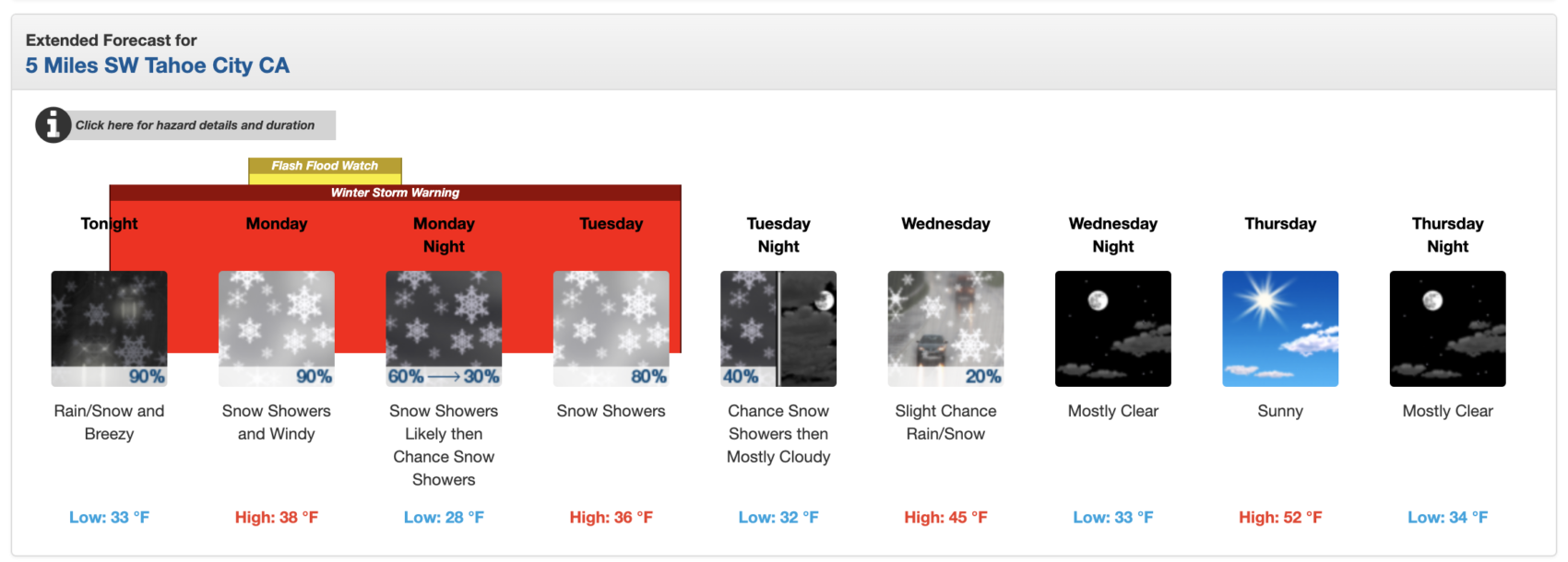
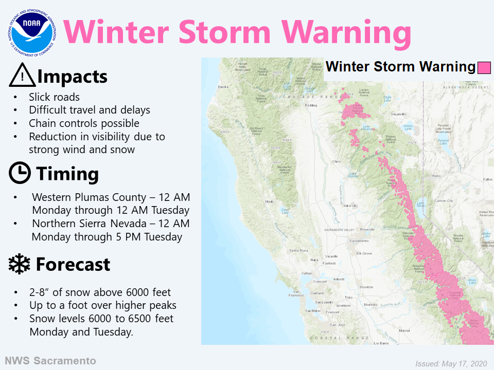
* WHAT...Heavy snow expected. Plan on difficult travel conditions, including during
the morning commute on Monday. Total snow accumulations of 6 to 9 inches, with
localized amounts up to 16 inches, are expected.
- NOAA, Reno NV, 5/17/20
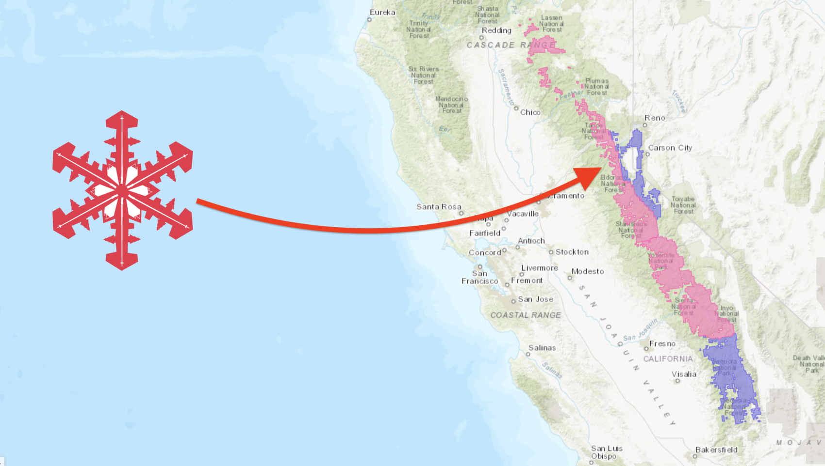
NOAA has issued a Winter Storm Warning for the west side of Lake Tahoe that is calling for 6-16″ of snow tonight through Tuesday.
“A spring storm will drive a cold front through the region with rain changing to snow as snow levels lower to near 7,000 feet by Monday morning.
Plan on slushy Sierra passes by Monday morning with 1 to 4 inches of wet snow possible between 7000 and 8000 feet with 4 to 8 inches possible above 8000 feet. Monday will also be the best potential for spillover rainfall across western Nevada valleys as the front moves through. Rainfall totals will generally be 0.25-0.75 inches in the valleys.
As colder air filters in behind the front, snow levels will continue to fall below 6,000 feet by Tuesday morning. Scattered snow showers are possible through the day Tuesday with isolated thunder and pellet showers possible. Some light snow will fall down to Lake Tahoe level and for much of Mono County, but ground temperatures may make road accumulations difficult. Some grassy surface may lightly accumulate.”
– NOAA, Reno NV, 5/16/20
Last year, Lake Tahoe saw non-stop snow for 9 days in the end of May and it was absolute fire.
Check out the video below of the best of Squaw Valley, CA in May 2019:
Winter Storm Warning for Lake Tahoe’s West Side
URGENT - WINTER WEATHER MESSAGE
National Weather Service Sacramento CA
1244 PM PDT Sun May 17 2020

...Snow Showers and Strong Wind for Higher Mountain Elevations
later tonight into Tuesday...

.Late season Pacific storm will bring periods of moderate snow
and strong wind to the higher elevations of the Sierra Nevada and
mountains of Western Plumas County late tonight into Tuesday.

Travel into the mountains should be avoided during this time
period as slick roads, lowered visibility, travel delays and
chain controls will be possible.

West Slope Northern Sierra Nevada-
1244 PM PDT Sun May 17 2020

...WINTER STORM WARNING REMAINS IN EFFECT FROM MIDNIGHT TONIGHT
TO 5 PM PDT TUESDAY ABOVE 6500 FEET...

* WHAT...Heavy snow expected. Plan on difficult travel
  conditions, including during the morning commute on Monday.
  Total snow accumulations of 6 to 9 inches, with localized
  amounts up to 16 inches, are expected.

* WHERE...West Slope Northern Sierra Nevada.

* WHEN...Midnight to 5 PM Tuesday.

* ADDITIONAL DETAILS...Be prepared for significant reductions in
  visibility at times.