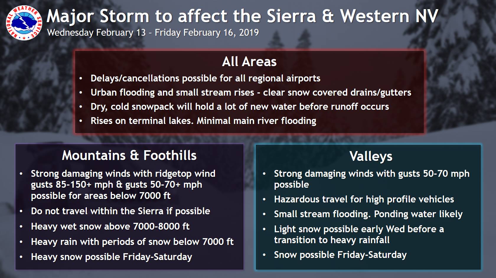
The National Weather Service has issued a Winter Storm Warning for California. It’s in effect until late Thursday evening. High winds and heavy snowfall are forecasted to impact the area throughout that time.
Storm Summary:
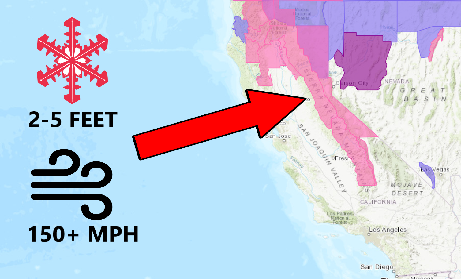
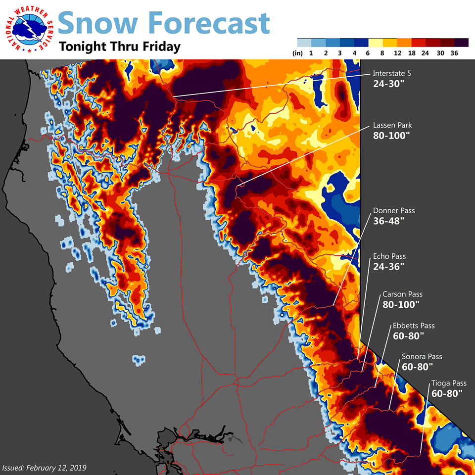
- 2-5 FEET of Snow Above 8,000ft Today – Thursday
- 150+ mph Ridge Gusts
“A major storm will arrive tonight and last through Thursday/early Friday. This system will be wetter and warmer than last weekend with heavy valley rain and heavy mountain snow possible. Winds will also be strong at times, particularly in the mountains, and area-wide by Thursday. Another colder system could impact our region Friday through the weekend. Prepare for the storm now. Tuesday is the last tranquil weather day through the end of the week.”
– NOAA Reno, NV
Snow levels are forecasted to start out around 5,000ft – 6,000ft before rapidly rising to 8,000ft Wednesday afternoon. On Thursday afternoon, snow levels are expected to drop back down to 6,000ft.
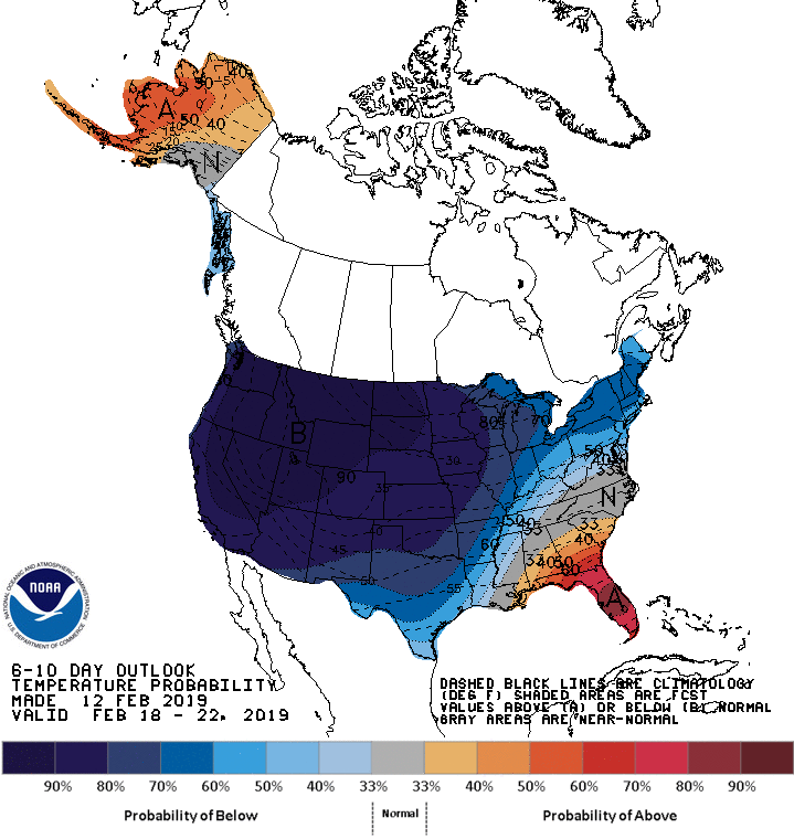
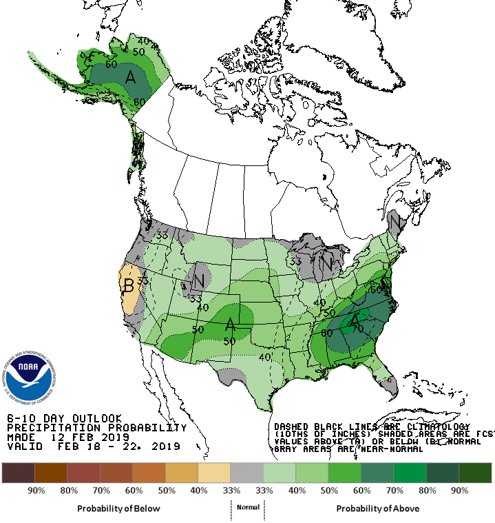
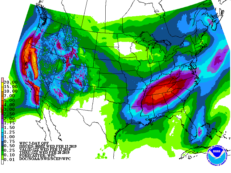
The 6-10 day outlook calls for below average precipitation and below average temperatures in California.
Additional Storm Info:
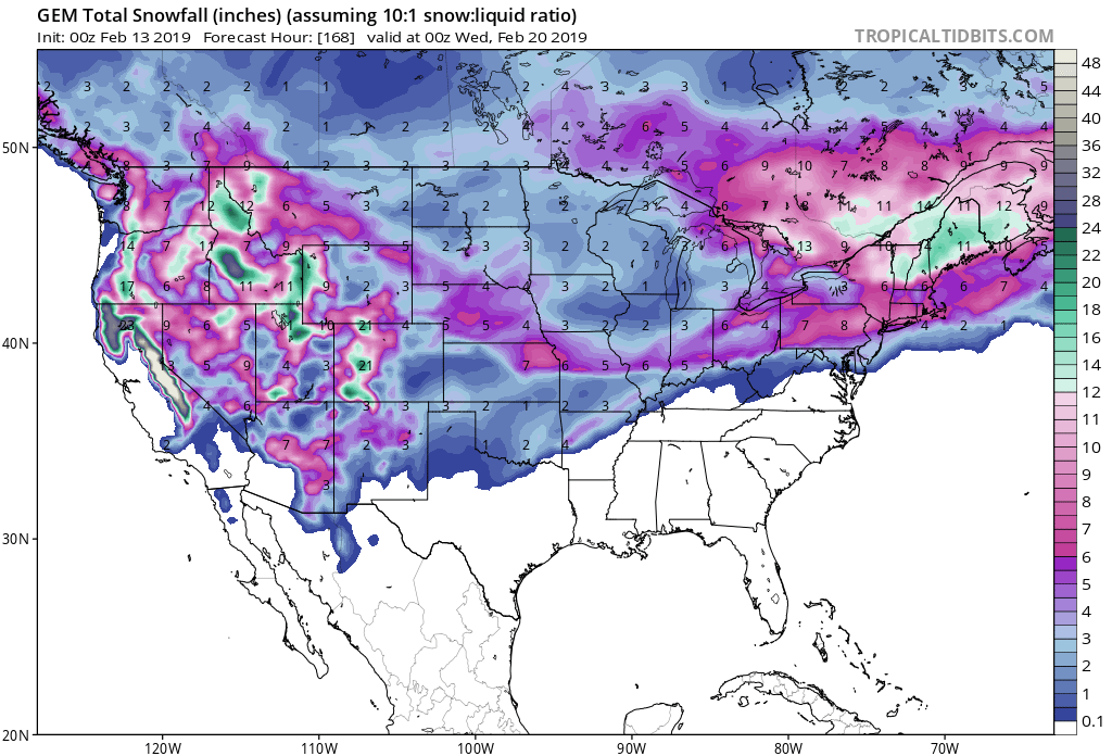
California: 2-5 FEET of Snow Above 8,000ft Today – Thursday
* Heavy snow possible above 7000 feet. Total snow accumulations
  of 6 to 10 inches for Truckee and South Lake, except 2 to 5
  feet possible above 8000 feet including Mammoth Lakes.
- NOAA Reno, NV
Winter Storm Warning:
URGENT - WINTER WEATHER MESSAGE
National Weather Service Reno NV
Greater Lake Tahoe Area-Mono County-
Including the city of Mammoth Lakes
1107 PM PST Tue Feb 12 2019

...WINTER STORM WARNING REMAINS IN EFFECT UNTIL 10 PM PST
THURSDAY ABOVE 7000 FEET...

* CHANGES...Adjusted snow level bullet.

* WHAT...Heavy snow possible above 7000 feet. Total snow
  accumulations of 6 to 10 inches for Truckee and South Lake,
  except 2 to 5 feet possible above 8000 feet including Mammoth
  Lakes. Winds could gust as high as 55 mph with ridge gusts
  possibly exceeding 150 mph.

* WHERE...Greater Lake Tahoe Area and Mono County.

* WHEN...From 10 PM Tuesday evening to 10 PM PST Thursday.

* SNOW LEVEL: Snow levels will start at 5000 to 6000 feet and
  will rise rapidly to near 8000 feet Wednesday afternoon and
  evening. Snow levels will then fall back below 6000 feet
  Thursday afternoon and evening.

* ADDITIONAL DETAILS...Travel could be very difficult to
  impossible. The hazardous conditions could impact the morning
  or evening commute. Very strong winds could cause extensive
  tree damage.