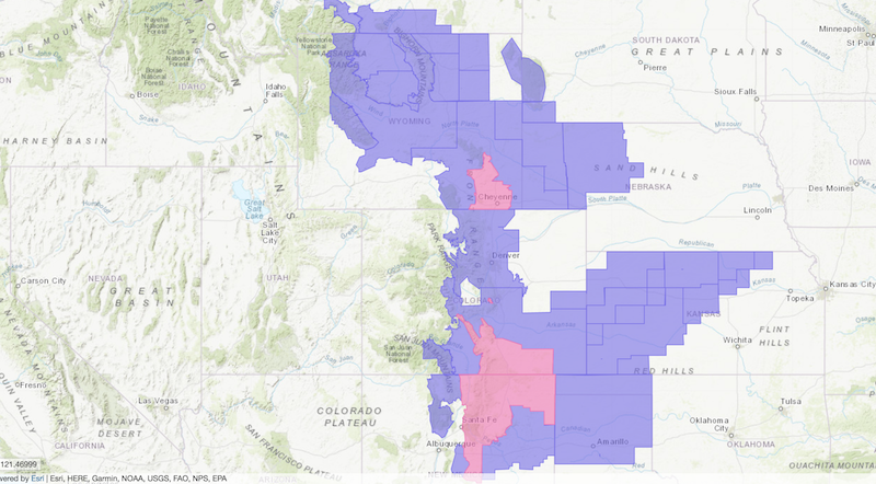
NOAA has issued Winter Weather Advisories across a large swath of the Rocky Mountains including Montana, Wyoming, Colorado, and New Mexico today.
- Montana = 2-4″ of snow forecast in southwest Montana.
- Wyoming = 5-9″ of snow forecast in the Front Range.
- Colorado = 8-16″ of snow forecast in the Sangro de Cristo range, Wet Mountains, and Pikes Peak.
- New Mexico = 6-14″ of snow forecast in Taos.
Montana:
- 2-4″ of snow forecast for southwest Montana.
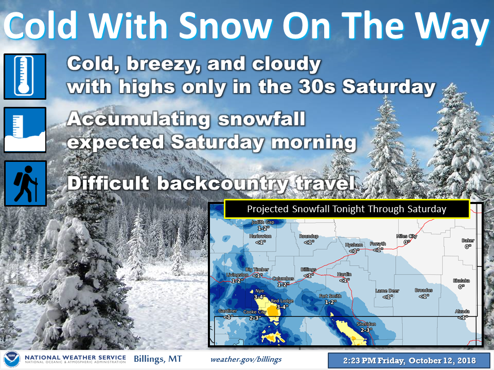
“We will start to warm up next week but not before another shot of cold and snow. Those with outdoor plans tomorrow should plan for cold, breezy, and wet conditions. Snowfall expected in the morning hours with the best accumulations along the foothills and mountain areas.” – snow
Winter Weather Advisory for Montana:
...WINTER WEATHER ADVISORY REMAINS IN EFFECT UNTIL 6 PM MDT THIS
EVENING...
* WHAT...Snow. Total snow accumulations of 2 to 4 inches expected.
Higher totals near the mountains.
* WHERE...Eastern Carbon and Southern Big Horn.
* WHEN...Until 6 PM MDT this evening.
* ADDITIONAL DETAILS...Plan on slippery road conditions. Expect
reduced visibilities at times. The heavy wet snow may down tree
limbs and cause power outages.
Wyoming:
- 5-9″ of snow forecast for the Front Range.

“A cold front will move southward through the day bringing widespread snow, mixed with rain at times, across the Cowboy State. Areas east of the Divide will have the biggest snowfall amounts and significant impacts. Winter Weather Advisories are in effect through tonight. It will be much colder today and Sunday behind the front.” – NOAA Riverton WY, today
Winter Storm Warning for Wyoming:
...First Significant Winter Weather of the Season to Bring Snow
and Much Colder Conditions to the area Tonight into Sunday...
.A potent disturbance aloft combined with an associated strong
cold front will sweep across southeast Wyoming and western
Nebraska Today into early Sunday, producing widespread snowfall
along with much colder temperatures.
...WINTER STORM WARNING REMAINS IN EFFECT FROM 6 PM THIS EVENING
TO 9 AM MDT SUNDAY...
* WHAT...Heavy snow expected, mainly this evening. Total snow
accumulations of 5 to 9 inches are expected, heaviest over the
South Laramie Range.
* WHERE...Central and western Laramie County, far eastern Albany
and southwestern Platte counties.
* WHEN...From 6 PM this evening to 9 AM MDT Sunday.
* ADDITIONAL DETAILS...Plan on very difficult travel conditions.
Expect significant reductions in visibility at times.
Colorado:
- 8-16″ of snow forecast in the Sangro de Cristo range, Wet Mountains, and Pikes Peak.
“Winter Returns Tonight! Cold temperatures & snow will spread quickly south this evening, resulting in slick & hazardous winter travel conditions that will stick around into Sunday. Prepare for the cold & snow now (drain sprinklers, car maintenance including ice scrapers and shovels, coats, gloves, hats, etc.)” – NOAA Denver CO, today
Winter Storm Warning for Colorado:
...WINTER STORM WARNING REMAINS IN EFFECT FROM 3 AM SUNDAY TO
6 AM MDT MONDAY...
* WHAT...Heavy snow expected. Total snow accumulations of 8 to 16
inches expected.
* WHERE...The Sangre de Cristo mountains, the Wet mountains and
the summit of Pikes Peak.
* WHEN...From 3 AM Sunday to 6 AM MDT Monday.
* ADDITIONAL DETAILS...Travel could be very difficult.
New Mexico:
- 6-14″ of snow forecast in Taos.
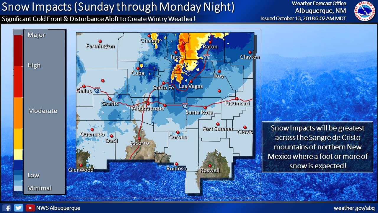
A winter storm will impact northern and eastern NM Sunday and early Monday. Get ready for a major change to significantly colder temperatures, bitter wind chills, heavy mountain snow in the Sangre de Cristo Mts, and freezing drizzle and freezing fog across eastern NM. If your are traveling to the north and east out of Albuquerque Sunday plan on deteriorating winter weather conditions. Check out the storm total snowfall and wind chill values for Monday morning.” – NOAA Albuquerque NM, today
Winter Storm Warning for New Mexico:
...AN EARLY SEASON WINTER STORM WILL BRING SIGNIFICANT TRAVEL
IMPACTS TO PORTIONS OF NORTHERN AND EASTERN NEW MEXICO SUNDAY
MORNING THROUGH MONDAY MORNING...
...WINTER STORM WARNING IN EFFECT FROM 6 AM SUNDAY TO NOON MDT
MONDAY...
* WHAT...Heavy snow expected. Total snow accumulations of 2 to 6
inches with 6 to 14 inches above 7500 feet. Snow will mix with
freezing drizzle or change to freezing drizzle at times across
Union County, the Central Highlands, the Northeast Highlands and
the Far Northeast Highlands.
* WHERE...Sangre de Cristo Mountains, Upper Rio Grande Valley,
Central Highlands, Raton Ridge and Johnson Mesa, Far Northeast
Highlands and Northeast Highlands, and Union County.
* WHEN...From 6 AM Sunday to noon MDT Monday.
* ADDITIONAL DETAILS...Significant reductions in visibility are
expected Sunday and Sunday night. Wet snow falling on lingering
foliage may result in isolated power outages. A flash freeze
will be possible during the first few hours after the onset of
precipitation, as arctic air causes water on road surfaces to
freeze rapidly.