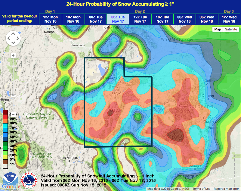
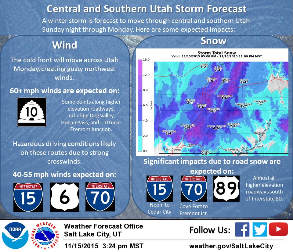
NOAA has issued a Winter Weather Advisory for Utah today through Monday night that is calling for 7-14″ of snowfall in the mountains. The system is forecast to split giving the southern mountains more snow than the northern mountains (ie the Wasatch).
NOAA is forecasting 7-14″ of snowfall in the mountains of Utah with the highest amounts in the south (ie not in the Wasatch).
* SNOW ACCUMULATIONS...7 TO 14 INCHES WITH THE HEAVIEST
  ACCUMULATIONS ACROSS THE SOUTHERN MOUNTAINS...3 TO 7 INCHES
  SOUTHERN MOUNTAIN VALLEYS. - NOAA SLC, UT today
***
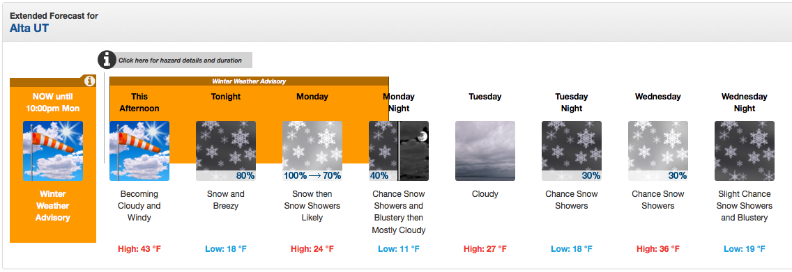
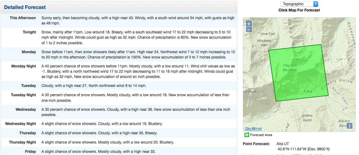
Alta, Utah is specifically forecast to see 4-9″ of snow from this storm according to NOAA’s local forecast.
***
***
So far, all the major storms hitting the Western US have figured out how to mostly miss Utah. No ski resorts are open yet in Utah.
Utah Ski Resort Opening Dates for 2015/16:
***
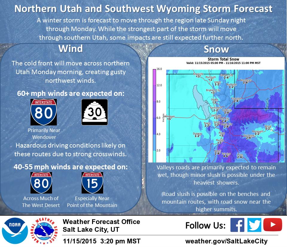
WINTER WEATHER ADVISORY for UTAH:
URGENT - WINTER WEATHER MESSAGE
NATIONAL WEATHER SERVICE SALT LAKE CITY UT
149 PM MST SUN NOV 15 2015
WASATCH MOUNTAINS SOUTH OF I-80-WESTERN UINTA MOUNTAINS-
WASATCH PLATEAU/BOOK CLIFFS-CENTRAL MOUNTAINS-SOUTHERN MOUNTAINS-
INCLUDING THE CITIES OF...ALTA...BRIGHTON...MIRROR LAKE HIGHWAY...
SCOFIELD...COVE FORT...KOOSHAREM...FISH LAKE...LOA...PANGUITCH...
BRYCE CANYON

...WINTER WEATHER ADVISORY IN EFFECT UNTIL 10 PM MST MONDAY...

THE NATIONAL WEATHER SERVICE IN SALT LAKE CITY HAS ISSUED A
WINTER WEATHER ADVISORY FOR SNOW...WHICH IS IN EFFECT UNTIL 10 PM
MST MONDAY.

* AFFECTED AREA...THE WESTERN UINTA MOUNTAINS...WASATCH
  PLATEAU...BOOK CLIFFS AND THE CENTRAL AND SOUTHERN MOUNTAINS.

* SNOW ACCUMULATIONS...7 TO 14 INCHES WITH THE HEAVIEST
  ACCUMULATIONS ACROSS THE SOUTHERN MOUNTAINS...3 TO 7 INCHES
  SOUTHERN MOUNTAIN VALLEYS.

* TIMING...SNOW...HEAVY AT TIMES...WILL QUICKLY MOVE INTO SOUTHERN
  UTAH THIS EVENING...THEN SPREAD NORTHEAST OVERNIGHT. SNOW WILL
  CONTINUE AT TIMES MONDAY...DECREASING MONDAY EVENING.

* WINDS...NORTHWEST WINDS GUSTING 30 TO 40 MPH MAY DEVELOP
  MONDAY...CAUSING AREAS OF REDUCED VISIBILITY WITH BLOWING AND
  DRIFTING SNOW.

* IMPACTS...MOTORISTS IN THESE AREAS SHOULD BE PREPARED FOR WINTER
  DRIVING CONDITIONS ACROSS ALL MOUNTAIN ROADWAYS.
Great information.