The National Weather Service has issued a Winter Weather Advisory for Oregon and Washington. It is in effect until Friday Night at 5pm. A cold front is expected to move through, which will lower snow levels as the storm progresses. Another round of snow is expected to impact the area throughout the weekend.
8-15″ of snow is expected to fall through Friday Night.
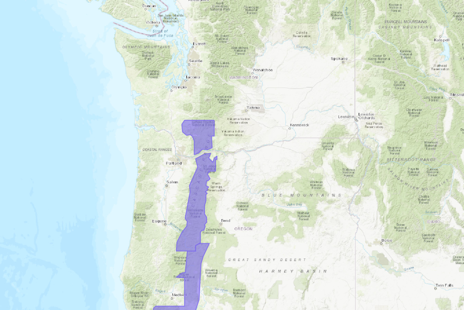
NOAA Has Issued A Winter Weather Advisory For:
- Oregon
- Washington
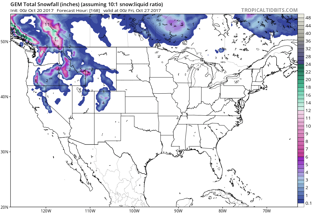
Snow levels are expected to drop throughout the storm, they will lower down to 4500-4000ft.
Additional Storm Info:
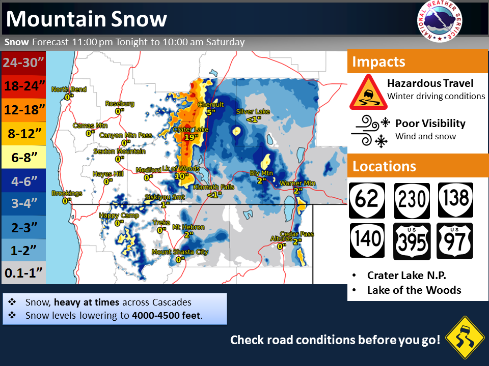
Oregon: 8-15″ of Snow Through Friday Night
* Total snow accumulations through Friday of 3 to 7
  inches at the passes and 8 to 15 inches at higher elevations.
  Snow levels around 4500 feet.
  - NOAA Portland, OR
Washington (Southern Portion): 8-15″ of Snow Through Friday Night
* Total snow accumulations through Friday of 3 to 7
  inches at the passes and 8 to 15 inches at higher elevations.
  Snow levels around 4500 feet.
  - NOAA Portland, OR


OR/WA Winter Weather Advisory:
URGENT - WINTER WEATHER MESSAGE
National Weather Service Portland OR
810 PM PDT Thu Oct 19 2017

South Washington Cascades-
Including the cities of Government Camp, Detroit, Santiam Pass,
McKenzie Pass, McKenzie Bridge, Oakridge, Willamette Pass,
Coldwater Ridge Visitors Center, Mount St. Helens,
and Wind River Valley

...WINTER WEATHER ADVISORY IN EFFECT UNTIL 5 PM PDT FRIDAY...

* WHAT...Snow occurring. Plan on roads becoming snow covered and
 slippery. Total snow accumulations through Friday of 3 to 7
 inches at the passes and 8 to 15 inches at higher elevations.
 Snow levels around 4500 feet.

* WHERE...In Oregon, Northern Oregon Cascades and Cascades in
 Lane County. In Washington, South Washington Cascades.

* WHEN...Until 5 PM Friday.

* ADDITIONAL DETAILS...Look for reduced visibilities at times.