Ready for that summer heat? Check out the Old Farmer’s Almanac’s latest forecast to see the Summer 2022 temperature and precipitation outlook for your area, compliments of Old Farmer’s Almanac meteorologist Michael Steinberg.
- How accurate was this? Old Farmer’s Almanac 2021/22 Winter Forecast: Longest and Coldest Winter for Years
A Scorching, Stormy Start
Summer officially begins with the summer solstice on Tuesday, June 21. We expect this season to start off with warm to hot temperatures and isolated thunderstorms across most of the United States, except for cool and wet conditions over the Appalachians and Ohio Valley.
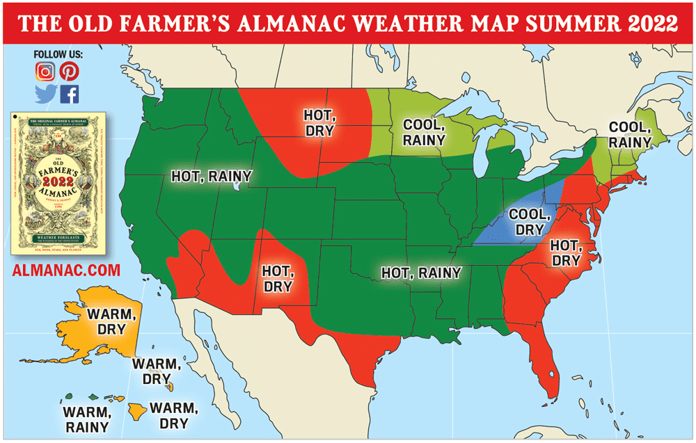
As for the rest of summer, the United States is in for another season of high heat. On average, we’re predicting summer temperatures to be hotter than normal across most of the country, ranging from the Atlantic Corridor south to Florida, across to the West Coast, and almost everywhere in between. Exceptions include the Northeast, eastern Ohio Valley, and Upper Midwest, which will luck out with cooler-than-average summer weather instead.
In most of the country, look forward to near- or above-normal precipitation to accompany summer’s high temperatures. In certain regions, however, rainfall will be lower than normal, including from southern New England southward to Florida, from the Appalachians westward through the eastern Ohio Valley, from southern Texas westward through the Desert Southwest, and across the northern High Plains, Alaska, and eastern Hawaii.
Lower rainfall amounts may result in drought conditions in some parts of the country, too. Specifically, we expect drought to be likely from southern Texas across the Desert Southwest, across the northern High Plains, and over parts of the Florida peninsula.
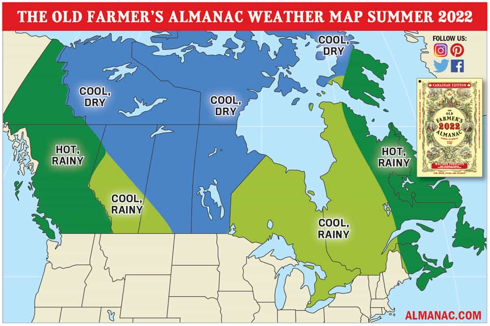
Summer in Canada
Across Canada, summer temperatures will be cooler than normal from Quebec westward to Alberta and northward to the Arctic Ocean. Elsewhere across the country, expect hotter than normal temperatures.
Precipitation will be below normal in Manitoba, most of Saskatchewan, northern Alberta, the Northwest Territories, and western and central Nunavut, but near to above normal elsewhere.
Another Active Hurricane Season
As you may know, June 1 marks the official beginning of the Atlantic hurricane season, which runs until November 30. We’re coming off of two very active years, thanks in part to the La Niña conditions in the Pacific. It looks like this season will feature near- or slightly above-average activity, with the La Niña weakening. If this season does indeed end up above average, it would be the seventh straight above-average season with regard to the number of named storms!
The best chance for a major hurricane strike will occur in Georgia or the Carolinas in mid-September, with tropical storm threats in Texas in mid- and late June, the Southeast in mid- and late August, and the Deep South in mid- and late July and late October.