Summary
A major winter storm will affect Colorado this week, bringing 1-2 feet of snow at most ski areas, with the highest totals being located at the furthest south and west resorts in the state. Said areas have the potential to get 40-50″ by the 27th with another large storm system on the way through the end of the month.
Short Term Forecast
There is a good model agreement that the first precipitation should begin on Thursday morning around 10 am in the mountains along the western slope of Colorado. Precipitation on Thursday should be mild, with maximum totals of just a few inches with the highest totals located in the Central Elk mountains near Aspen and Crested Butte. Here’s a blended model output of forecasted snow by midnight on Thursday:

Precipitation will gradually increase overnight heading into Friday morning. By the time lifts are spinning on Friday, many resorts in the central and northern mountains will likely have 5-12″ of snow. Resorts near I-70 will be on the lower end of this scale with Aspen and Steamboat leading the charge with a foot or more. Crested Butte, which does well with this southwest wind pattern, could see up to 18″ by Friday morning.
The San Juan Mountains in southern Colorado, with resorts like Silverton, Telluride, and Wolf Creek, will do very well by Friday morning. Silverton and Wolf Creek should have 18-24″ by the time lifts are running that morning.
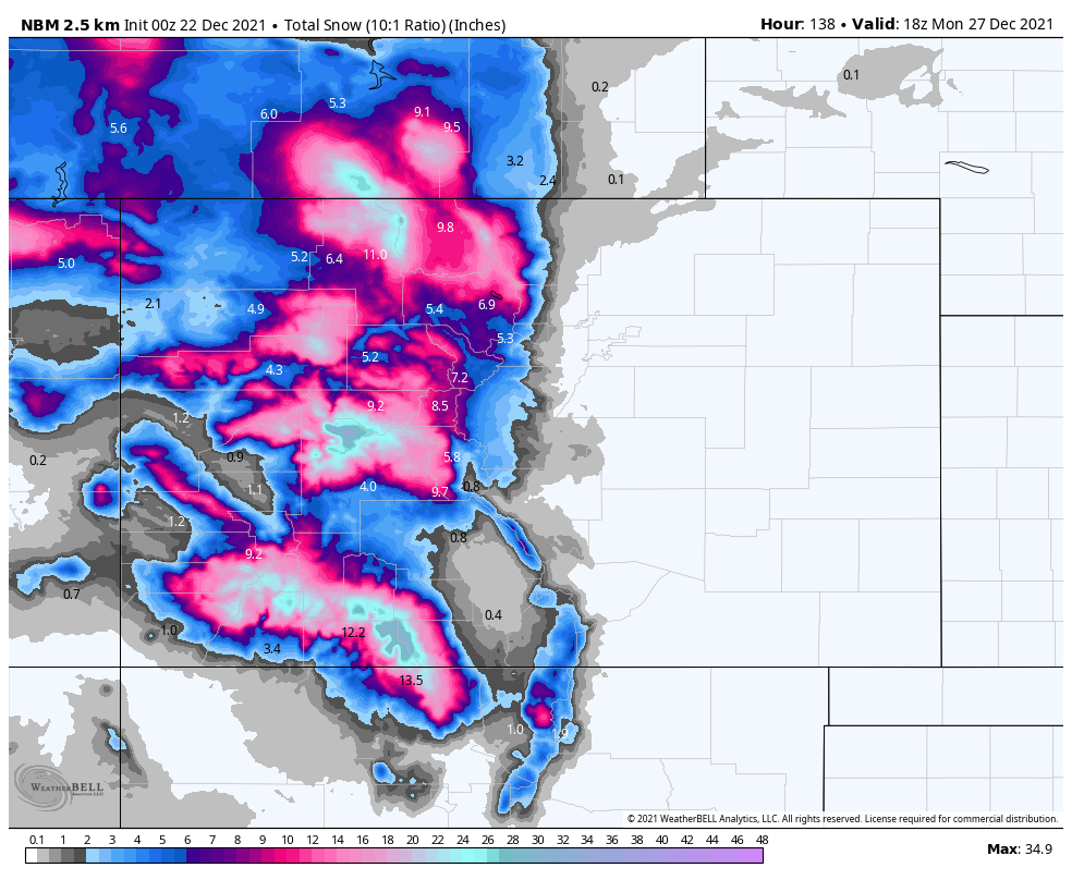
Steady snow will continue to fall throughout the state into the afternoon of Monday the 27th. The weekend should see average snowfall rates of ~0.5″ per hour for mountains south of Aspen and ~0.25″ per hour for mountains north of Aspen (except for Steamboat, which will be higher). As was the case earlier in the storm, the best skiing will be in the central and southern mountains. Here’s what things might look like on Monday morning. Multiply precipitation by about 12 to get a conservative snow forecast:

Here are the realistic possible ranges that I see for resorts around the state by Monday morning:
- Steamboat – 20-34″
- Winter Park – 7-12″
- Loveland/Arapahoe Basin – 11-15″
- Vail – 15-23″
- Snowmass – 24-35″
- Crested Butte – 37-52″
- Telluride – 24-36″
- Silverton – 27-41″
- Wolf Creek – 42-55″
Extended Forecast
Things are looking great heading into the New Year. Another storm is expected on the 28th which could end up being as strong or stronger, and precipitation is forecasted to linger into January. I’ll do an updated forecast for that storm system later this week or this weekend, but I have hope that the next 10 days of storms could propel Colorado back to average or even above-average snowpack by the start of 2022.