Forecast published at 8 a.m. Mountain Time on March 18, 2025.
The Pacific Northwest will see multiple waves of snowfall this week, with the heaviest accumulations expected from midweek through the upcoming weekend, but a notable warmup could introduce rain-on-snow for some areas by late Sunday into Monday. Overall, cooler temperatures will persist through much of the workweek, allowing moderate to occasionally heavier snow accumulations at pass level and above, before snow levels climb significantly late in the weekend.
Lingering snow showers will wind down across the region on Tuesday. In the higher mountains of the Idaho Panhandle and Oregon Cascades, intermittent snow continues through Tuesday afternoon, dropping a light layer of fresh snow at higher elevations. Snow quality in this midweek lingering activity will lean toward the wetter side (SLRs generally below 10:1), and though it’s modest, it sets the stage for the more significant storm cycle beginning Wednesday.
From Wednesday into Thursday, a more robust system surges into the Cascades. Initial snow levels in Washington will hover around 3,000 feet, while in Oregon they’ll climb closer to 4,000-5,000 feet later Wednesday before dipping again. Several resorts in the Washington Cascades will likely see advisory to warning-level totals, with particularly strong showings around Mount Baker and Mount Rainier areas. Oregon’s higher elevations above 5,000 feet are also favored, where amounts of a foot or more are increasingly likely. However, snow densities will be on the heavier side (often 6-10:1 SLRs), so expect less of the champagne feel and a bit more moisture in the flakes. Blustery southerly winds will also factor in, especially on Wednesday night into Thursday.
A secondary push arrives late Thursday into Friday. This wave will keep snow showers rolling in the Washington and northern Oregon Cascades, with a decent chance of continued advisory-level totals. Breezy conditions remain, with gusty winds across the Columbia Basin spilling over into the mountains. Snow levels should remain near or just below pass elevations, ensuring continued accumulation at ski areas. Snowfall quality stays moderate at best, given that SLRs stay in the same ballpark as earlier in the week, but the consistent refresh should keep surfaces relatively fresh.
The weekend ushers in another unsettled spell but with rising snow levels by Sunday into Monday. Heavier precipitation is on tap for the Washington Cascades in particular, although temperatures will climb, potentially topping out near 7,500 feet late Sunday. This could translate to rain-on-snow or a mix at mid and lower elevations. High-elevation resorts may still pick up new snow, but it will likely be wetter as SLRs may drop further in the warmth. Looking into the medium range, the Pacific Northwest seems poised to see continued above-normal precipitation, so more storms could spin through, however, the strengthening spring sun and warmth may gradually erode snow quality below about 5,000 feet.
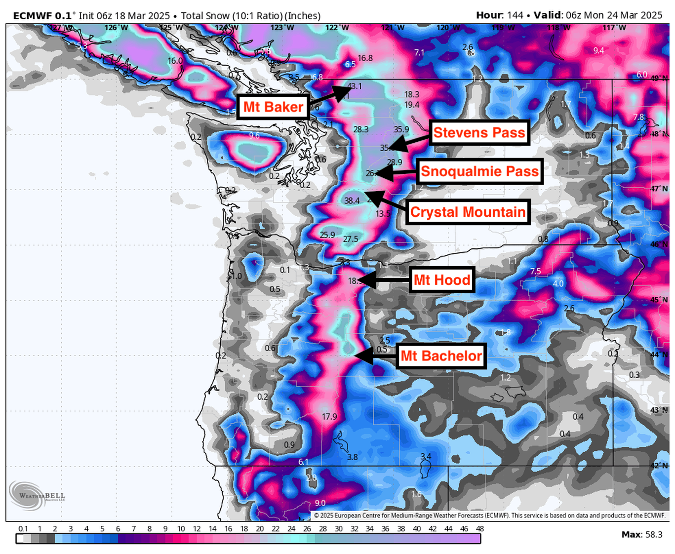
Resort Forecast Totals
- Timberline – 15”-28” total (1”-3” Mon night (03/17) – Wed (03/19) + 14”-25” Wed (03/19) – Sun night (03/23))
- Stevens Pass – 15”-27” Wed (03/19) – Sun night (03/23)
- Whistler – 14”-26” total (10”-17” Tue night (03/18) – Sat night (03/22) + 4”-9” Sat night (03/22) – Sun night (03/23))
- Mt Baker – 14”-25” Wed (03/19) – Sun night (03/23)
- Mt Bachelor – 13”-23” total (1”-2” Mon night (03/17) – Tue night (03/18) + 12”-21” Wed (03/19) – Sun night (03/23))
- Crystal Mountain – 12”-21” Wed (03/19) – Sun night (03/23)
- Snoqualmie Pass – 11”-20” Wed night (03/19) – Sun night (03/23)