Forecast By SnowBrains Meteorologist – Eric McNamee
Brought to you by Alta Ski Area
12:30 PM MST, 1/18/2021
Forecast Summary:
1-2 FEET of snow is expected across the West through the weekend as a pattern shift takes place over the Western US.
The shift will begin today a shortwave trough digs in from Canada down into the desert Southwest.
This will help pave the way for more shortwave troughs to dig into the western US as the ridge of high pressure weakens and shifts off the West Coast.
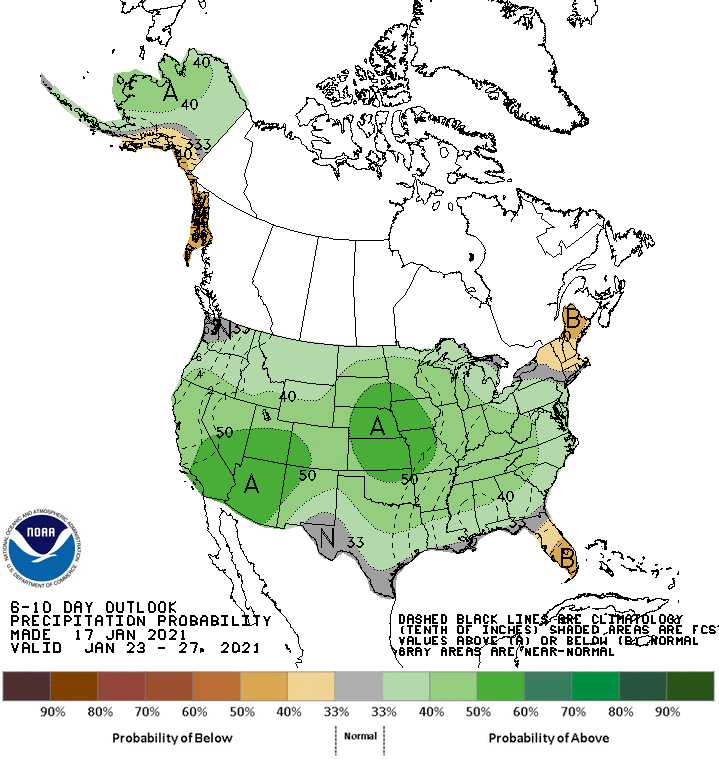
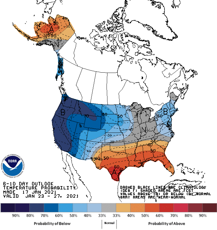
Conditions look to remain active with above-average precipitation and below-average temperatures across the West in the extended.
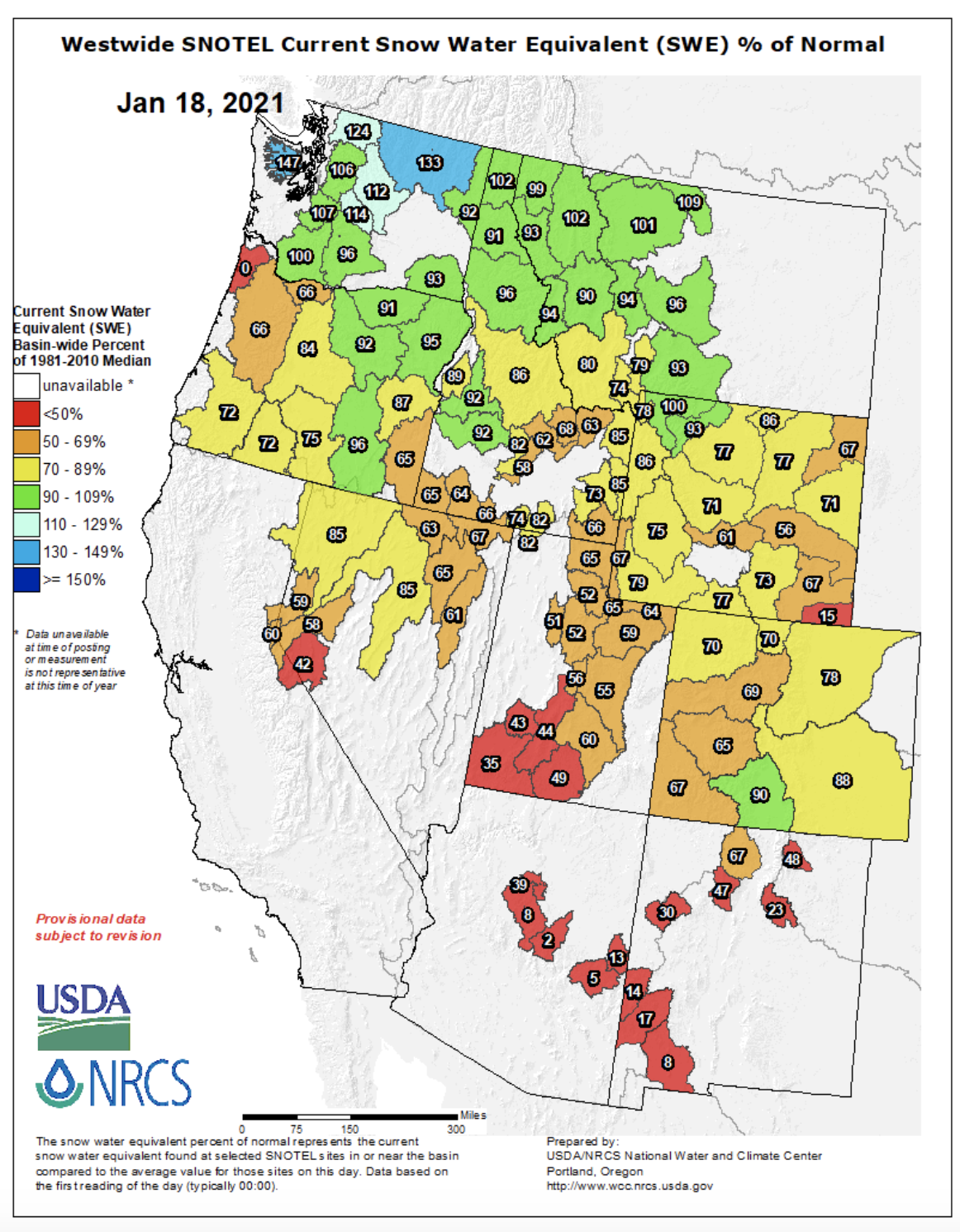
Snowpacks in the Western USA are largely well below average to date (see image below).
Short-Term Forecast:
Monday-Wednesday:
A shortwave trough located along the US/Canadian border will dig into the Desert Southwest today and tomorrow, bringing 6-12″ of snow to southern Colorado/northern New Mexico through Tuesday.
This shortwave trough, along with another that will miss the West, will weaken the ridge of high pressure that’s been in place for the past couple of weeks.
This will open the door for more shortwave troughs to move through the Western US.
Long-Term Forecast:
Thursday-Sunday:
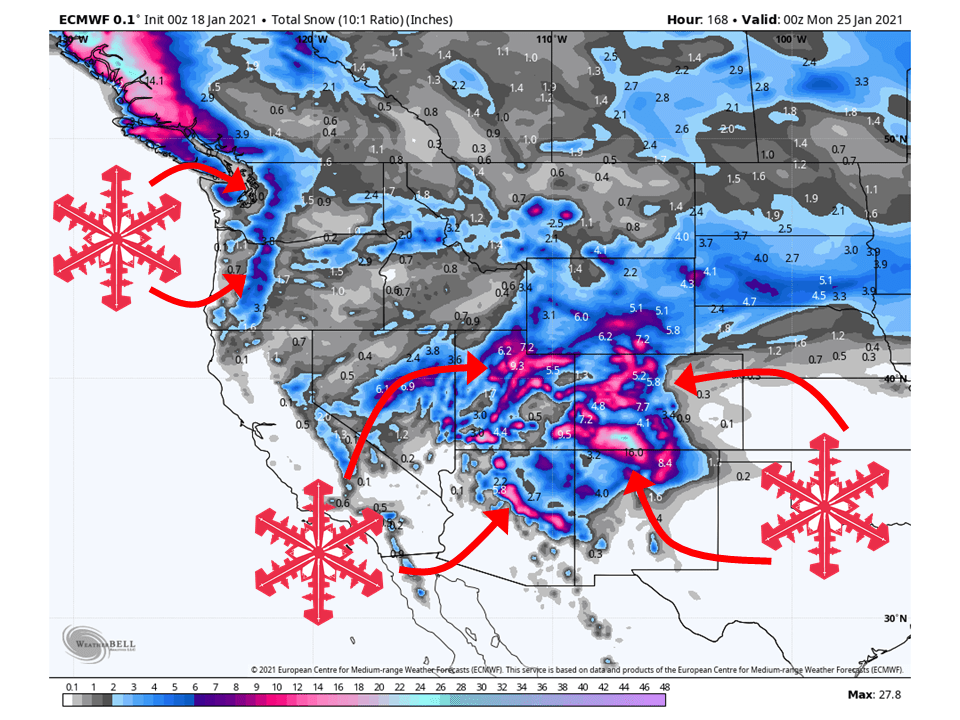
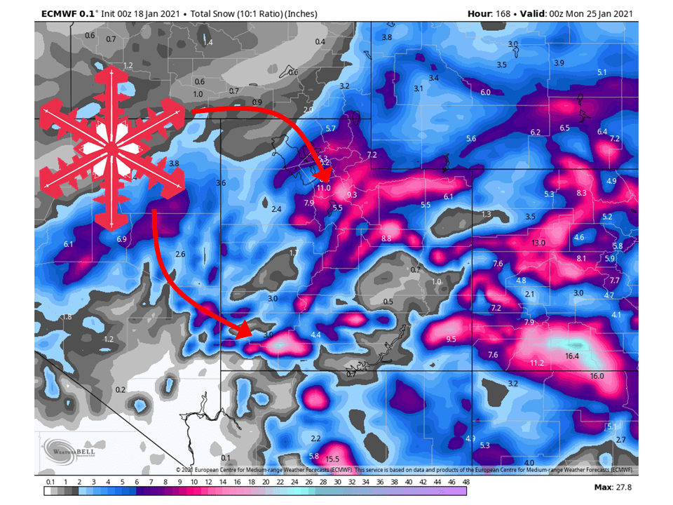
This next shortwave trough will dig into the Western US Thursday/Friday and deepen, bringing 6-18″ of snow to Utah, Colorado, Arizona, and New Mexico through the weekend.
Another shortwave trough will dig into the West this weekend, bringing possibly high amounts to the West Coast.
This shortwave is still 6+ days out, so exact amounts are uncertain at this time.
Extended Forecast:
Sunday and Beyond:
Global ensembles are indicating the pattern to remain active with above-average precipitation and below-average temperatures across the West.
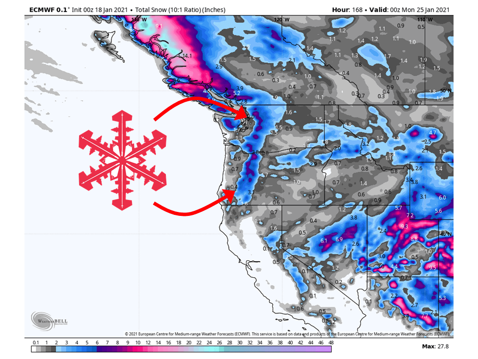
Utah:
The first of two shortwaves will move through the state today and tomorrow, bringing 1-2” of snow to the mountains.
A more robust and deeper trough will dig into the region Friday, bringing 6-12″ of snow to most mountain locations
Resorts that look to be favored are Alta, Snowbird, Brighton, Solitude, Park City, Canyons, Deer Valley, Snowbasin, Powder Mountain, Beaver Mountain, and Brianhead.
**Alta Forecast**
Light snow today as a weak shortwave trough moves the state, bringing 1-2″ of snow to the Wasatch.
A more potent and deeper trough will dig into the Great Basin Friday and intensify.
This looks to bring 6-12″ of snow to the mountain through Saturday.
More snow is possible through the extended.
California:
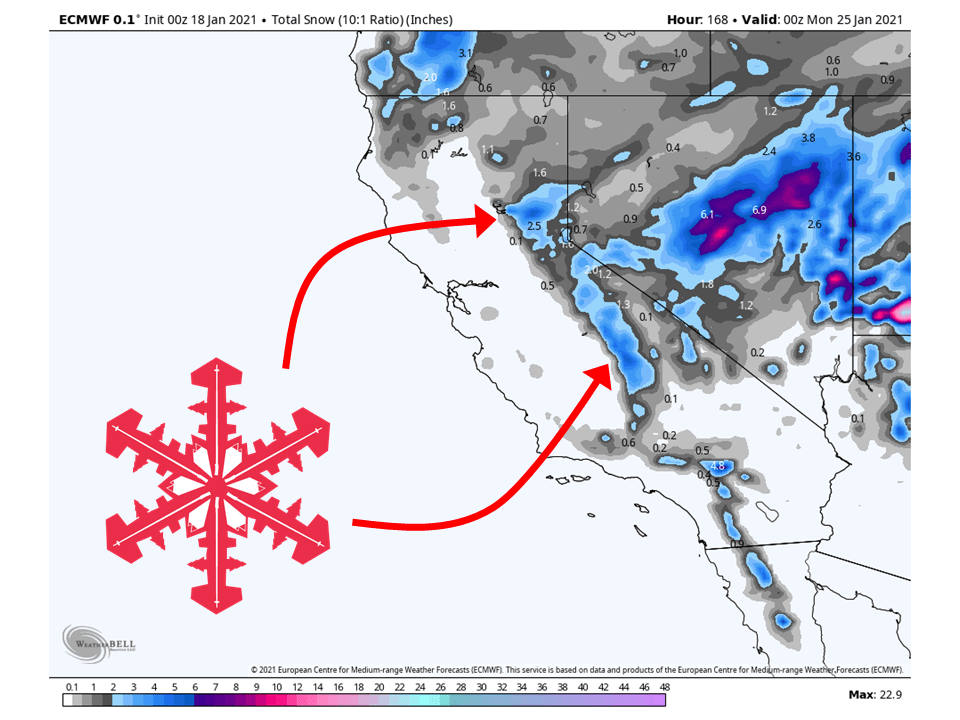
California will remain relatively dry through most of the forecast, with the expectation of 1-4″ of snow falling in the long-term.
The state looks to see more actions in the extended.
Resorts likely to get the most snow are Boreal, Kirkwood, Sugar Bowl, Squaw, Alpine, Northstar, Homewood, Heavenly, and Mammoth.
Pacific Northwest:
Like California, THe Pacific Northwest looks to stay relatively dry through most of the forecast, with the expectation of 1-4″ of snow falling in the long-term.
This weekend and early next looks like there is a good chance for more significant snowfall with an active pattern staying in place.
Resorts that look to see the most snow are Mt. Bachelor, Mt. Hood, Timberline Lodge, Crystal Mountain, Alpental, and Mt Baker.
Northern Rockies:
The northern Rockies will see at least 2-5″ snow through the week as shortwaves brush by the region.
Resorts that look to see the most snow are Jackson Hole, Targhee, Big Sky, Whitefish Mountain, and Schweitzer.
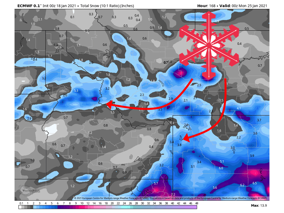
Colorado:
Colorado will see 6-18: of snow over this next week as shortwave trough take aim at the state.
The first of said shortwaves will move through the area tomorrow, 6-12″ of snow to the San Juans.
The second shortwave will move through the weekend, bringing more widespread snowfall and an additional 6-12″ to the mountins.
Resorts that look to see the most snow are Aspen, Steamboat, Wolf Creek, Telluride, Silverton, and Winter Park.
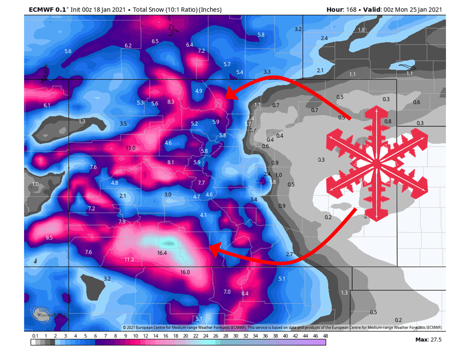
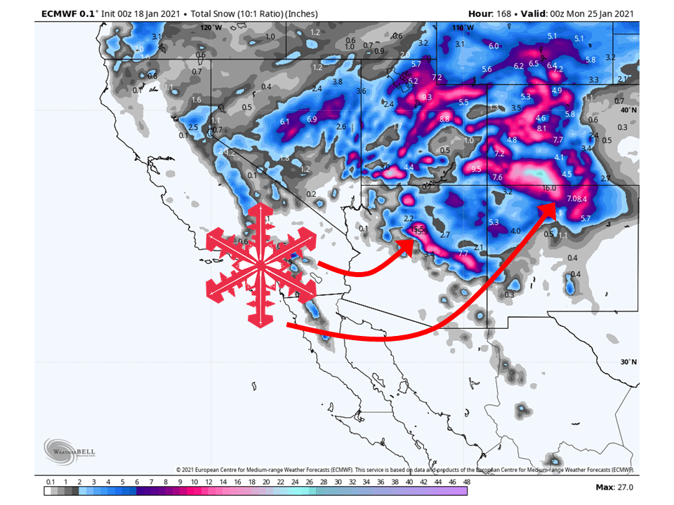
Southwest:
The Southwest will see their high snowfall totals this season as two shortwave troughs bring 6-18″ of snow through this week.
The first will move through tomorrow and Wednesday, bringing 6-10″ of snow to New Mexico and 2-5″ to Arizona.
The second shortwave will move through this weekend, bringing 6-14″ of snow to the higher elevations.
Resorts likely to see the most snow are Arizona Snowbowl, Taos, and Ski Santa Fe.
USA:
Global ensembles are indicting that conditions will remain active with above-average precipitation and below-average temperatures across the West in the extended.
Hey, I’m going on a trip to ski the Cotton Wood Canyon resorts on the 25-29th of this month and other than the snow the fri-sat before right before those dates will there be any snowfall during the week?
Doesn’t look like anything else this week besides the system this weekend. However, ensembles are showing increased chances for storminess on the dates you are visiting. Snowfall amounts are not certain since it is about a week out but it is looking promising. Make sure to stay tuned for more forecasts this week!