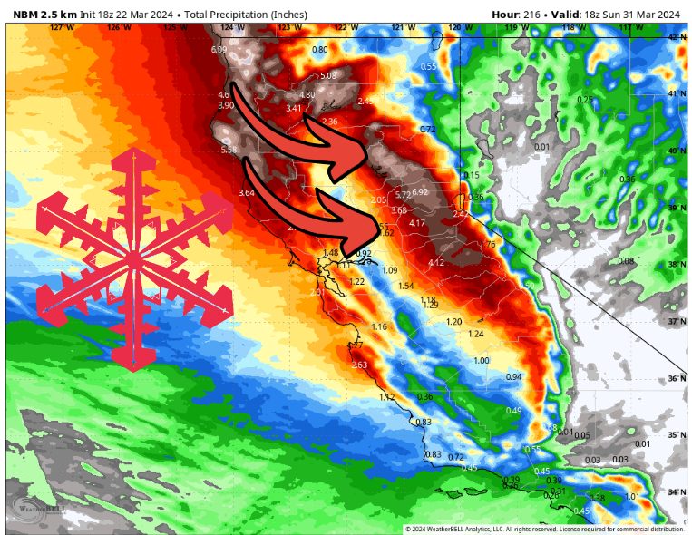
Inches of precip will accumulate in California this week. Source: maps.weatherbell.com
Forecast prepared the evening of Friday, March 22
Forecast Summary
The dry break is over for California, with a couple of low pressure systems bringing large swaths of rain and snow to the state starting Friday night.
The rest of March in the Sierra’s will feature intervals of heavy snow, snow showers, and only brief dry periods.
Expect 3-6″ of liquid across much of the Sierra’s by the end of next weekend, with some resorts seeing as much as 7′ of snow.
This Weekend
The first storm begins producing rain and high mountain snow Friday night ahead of a cold front that arrives early Saturday morning. Snow levels drop from ~7,000ft to ~4,000ft after the cold front moves through, allowing any lower elevation spots to start seeing accumulating snow by sunrise Saturday.
Snow will be heavy at times Friday night, especially across the highest terrain. As the front moves through, snowfall rates backoff slightly, although snow continues mostly uninterrupted through Sunday afternoon.
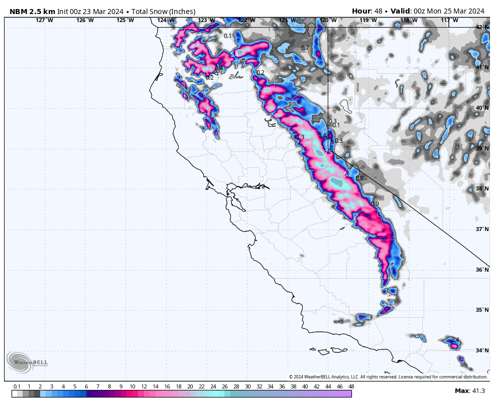
Snow totals through Sunday afternoon. Source: maps.weatherbell.com
Friday night – Sunday afternoon snow totals:
- Donner Pass – Boreal, Sugar Bowl, Soda Springs: 16-28″
- Palisades: 12-24″
- Heavenly: 5-10″
- Mt. Rose: 6-10″
- Kirkwood: 15-30″
- Mammoth: 10-18″
Next Week
There is a brief dry period Sunday night into Monday afternoon before scattered snow showers start popping up again. These showers continue at times through midday Wednesday, with a few inches possible here and there, but nothing organized or consistent. Snow levels will sit near 5,000ft Monday and Tuesday, but rise to ~6,000ft Wednesday morning.
This lull in the action is interrupted by another cold front that arrives near midnight on Wednesday night. Rain/snow becomes more widespread several hours ahead of the cold front, with snow levels close to 5,500-6,000ft Wednesday evening. When the front arrives, snow levels drop to as low as 3,000ft, and snow:liquid ratios rise to between 12:1 and 15:1.
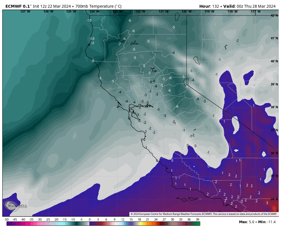
Colder air rushing in Wednesday night. Source: maps.weatherbell.com
As with this weekend’s storm, the heaviest snow falls just before and just after the cold front. Between 1-2″ of liquid is expected Wednesday night – Thursday morning, with resorts seeing about 1-3′ of additional snowfall.
Snow continues at times through Friday before yet another cold front sweeps through Friday night. Snowfall rates will once again increase dramatically in association with this front, producing another 1+” of liquid with similar snow:liquid ratios as Wednesday night. Scattered snow showers continue Saturday, ultimately tapering off sometime Sunday.
Next week as a whole should produce another few feet of snow across the Sierra’s, with the vast majority of that falling Wednesday night – Saturday morning.
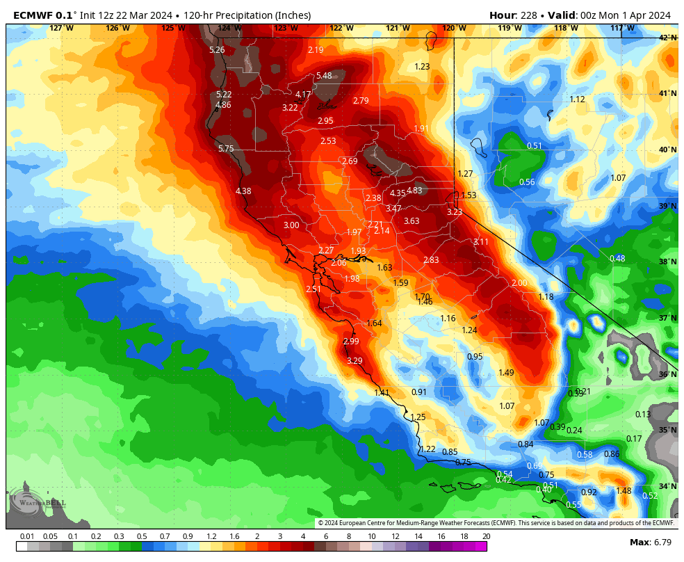
Total precip accumulation between Monday-Sunday. Source: maps.weatherbell.com
Monday – Sunday snow totals:
- Donner Pass – Boreal, Sugar Bowl, Soda Springs: 30-60″
- Palisades: 25-50″
- Heavenly: 12-24″
- Mt. Rose: 12-22″
- Kirkwood: 30-50″
- Mammoth: 24-40″