
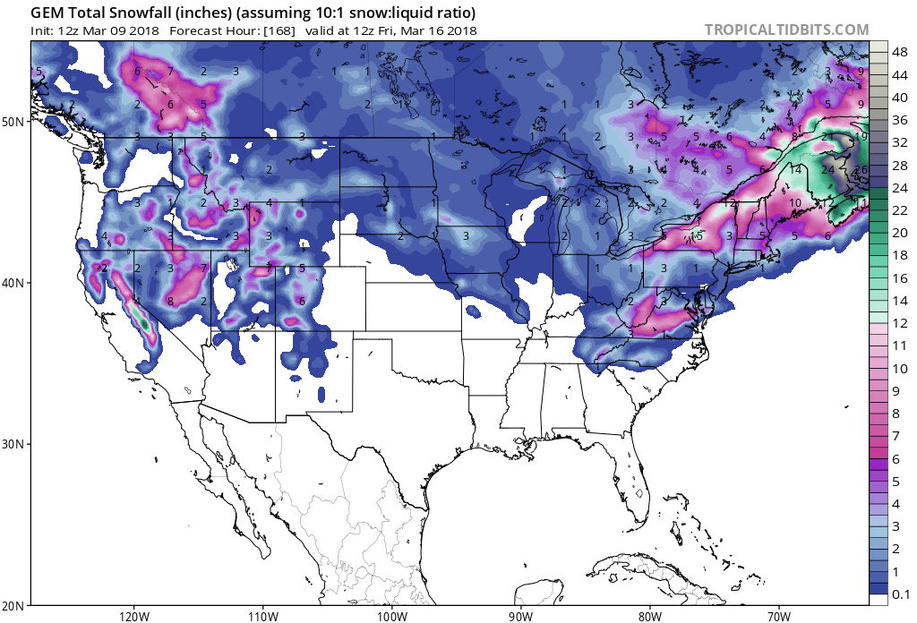
Another round of snow is headed to California. It’s forecasted to impact the area Monday Night through Wednesday Night. The long term forecast calls for below average temperatures and above average precipitation in California, so it could be a good end to the season.
1+ FEET of Snow For The Mountains Monday Night – Wednesday Night.

Snow levels are forecasted to hover between 6,000ft and 7,000ft throughout the duration of the storm.
Additional Storm Info:
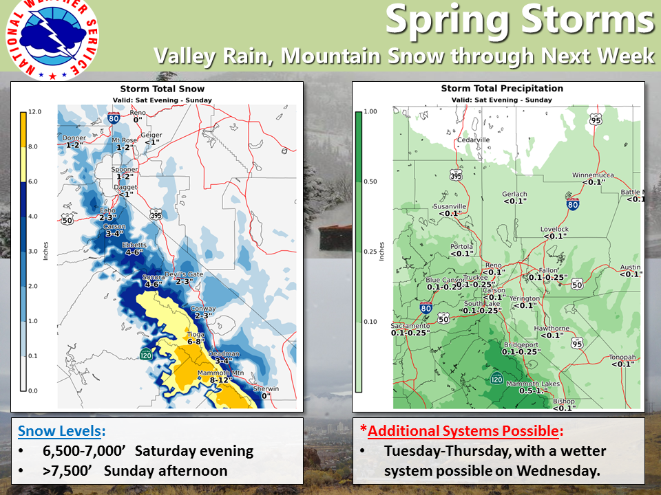
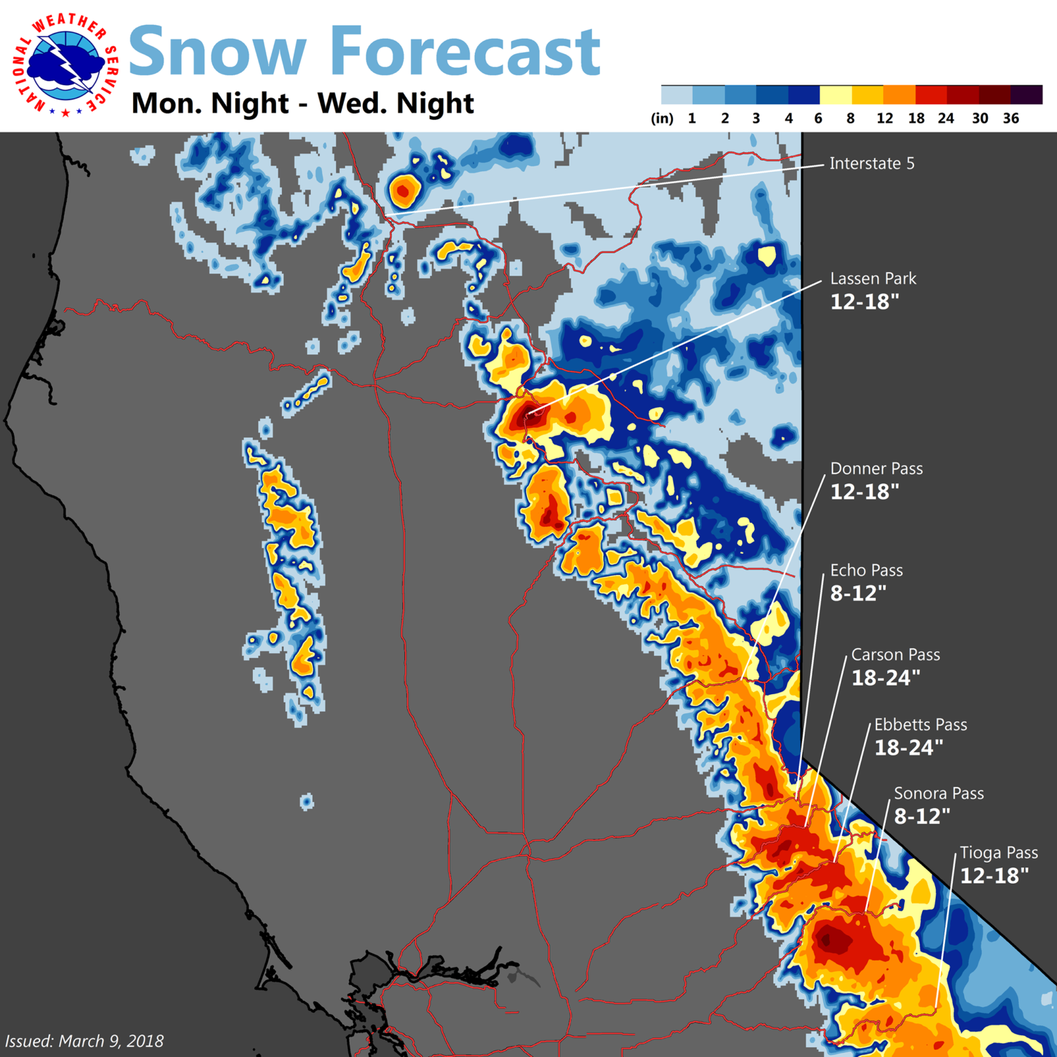
California: 1+ FEET of Snow For The Mountains Monday Night – Wednesday Night


CA Long Term Forecast:
  .LONG TERM...Monday through Thursday...

  Minor changes were made to the inherited forecast to account for
  variations in model solutions.

  There is fair agreement early in the forecast that slows the
  progression of the first part of the next overall system moving into
  the region. This should promote slight stronger winds for Monday...
  if this solution comes to fruition...and a slight reduction in pops
  for most of Monday.

  The operational GFS and ECMWF move this main upper low closer to the
  region by early Tuesday and begins spreading better chances for
  precipitation into the area. Snow levels remain rather high early in
  the life cycle of this system...but begin to fall late Tuesday into
  Wednesday. The ECMWF remains a little cooler overall than the
  GFS...so changes made to snow levels were minimal to account for the
  cooler ECMWF solution.

  Differences in the model solutions become more amplified by
  Wednesday/Thursday. The ECMWF is a little faster bringing heavier
  QPF into the area Wednesday while the GFS has its greatest QPF
  Thursday. This has a lot to do with the GFS holding the main low
  offshore for a longer period of time and the ECMWF becoming more
  aggressive with rotating waves around the main upper low and
  impacting the region faster Tuesday and Wednesday.

  The GEFS ensemble members vary from a progressive trough moving
  through the region by Thursday to a closed/cut off low offshore. If
  the low trends more toward a cut off solution we would likely see
  less precipitation...and warmer temperatures...north of Highway 50.
  If the ECMWF solution verifies...there would likely be more
  precipitation into western Nevada and cooler overall temperatures
  with more snow in the Sierra. Right now it may be way too early to
  lean toward any particular solution given the variations in the
  model guidance.
This isn’t Spring. Not until March 20th. Get it right or pay the price