POSTED: April 6th, 2017
by Squaw Valley
The storm has started moving in. Today both mountains experienced extremely high and intense winds, which limited operations. The good news is we could see up to 4 feet on upper elevations by Sunday/Monday! Let’s take a look at what this weekend’s weather will bring.
Check out NOAA (National Weather Service) sensors from today:

PROJECTED OPERATIONS FOR TOMORROW AND THE WEEKEND
Friday, April 7
Tomorrow could be much of the same as today: excessive winds, which likely will impact our operations.
“Winds will increase today and continue into Saturday morning ahead of an incoming atmospheric river storm. The strongest winds are expected this afternoon and again Friday afternoon. Multiple rounds of heavy rain and higher elevation snow will occur tonight through Friday night with snow and snow pellet showers bringing additional accumulations Saturday even down to western Nevada valley floors.” – NOAA Weather Discussion
Stay tuned to the app and website for real-time operational information tomorrow and throughout the weekend.
Saturday & Sunday, April 8-9
Saturday will be our hardest operating day with the Atmospheric River moving in (this is our 10th this season). Saturday will be a snow safety day and high winds will be present, which will again affect operations. As NOAA states…
“The well advertised Atmospheric River (AR) storm is on track to reach the region tonight, with a myriad of significant impacts possible through Saturday. This includes heavy rain and mountain snow, major travel impacts, possible flooding, and strong winds. The AR would be categorized as a solid moderate event, with an uptick in ensembles bordering on strong. This is a highly unusual event for April with the forecast liquid precipitation 2-day totals in some locations having not been observed in 10-20 years.”
Operations will likely be imapcted and will have a limited offering, but Sunday and Monday should be calm(er) and potentially provide some awesome powder skiing in April. We won’t know too much until we get to this point, so stay tuned here to the operations blog as things unfold, the app and website for real-time information.
ANOTHER STORM POSSIBLE NEXT WEEK
Next Wednesday night through Friday another cold storm may bring additional snowfall. It could come in feet again on the mountains. That will be the focus after this storm.
The pattern could remain active through April.
BA – Resident weather blogger
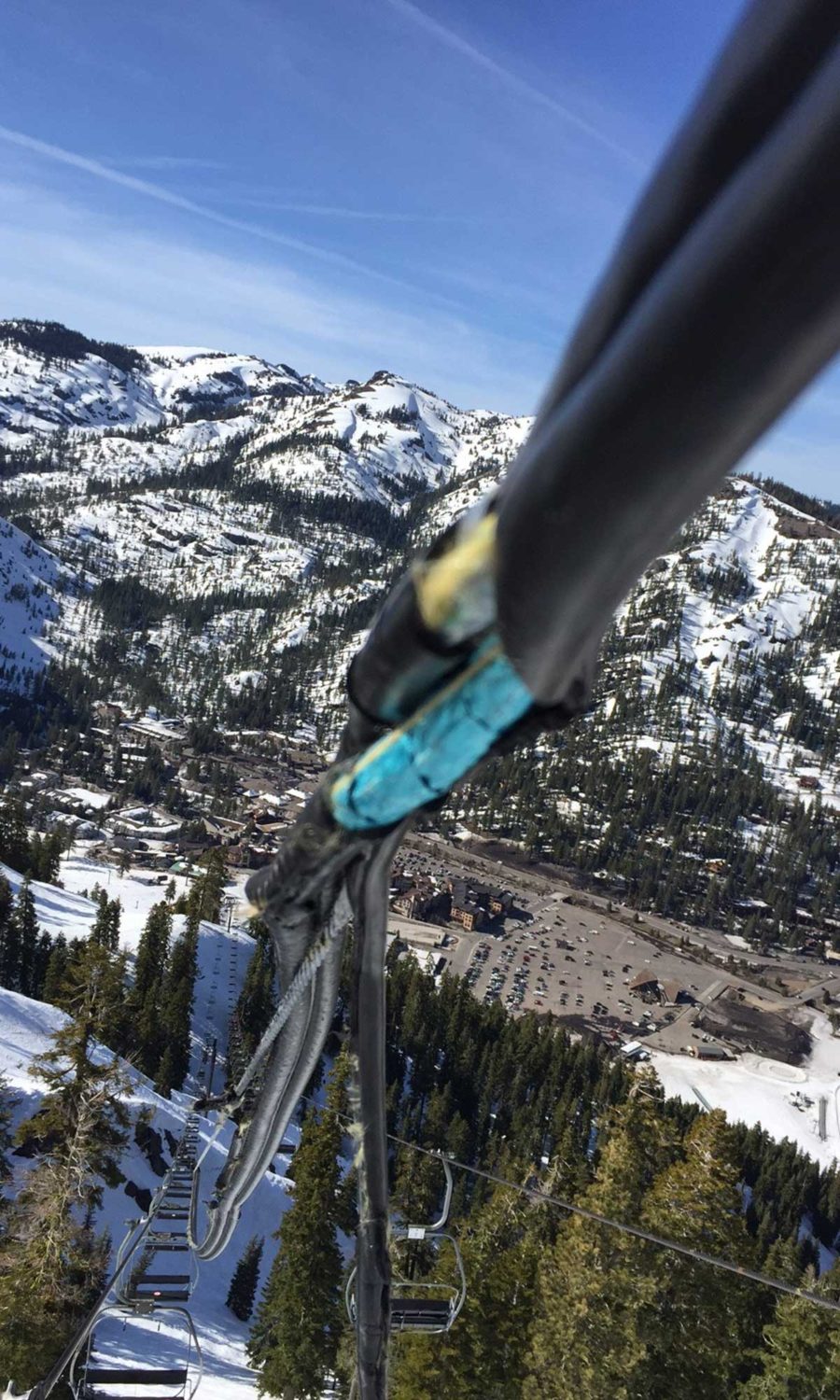
RED DOG MECHANICAL CLOSURE
Red Dog’s communication line was damaged by wind. This is the aerial wire that runs the length of the lift between the upline and downline ropes and allows the towers and terminals to communicate with the computer system and controls. The communication wire has separated from the cable and wrapping. Due to the amount of slack on the comline, there is a big risk of entanglement with chairs. Therefore, we cannot operate Red Dog in this wind damaged condition. We were able to locate and order a replacement comline section Tuesday. We have contracted with Leitner-Poma to assist with replacement next week, following the storm and it could be a 4 day project. This means Red Dog will be out of service during the upcoming storm.
“With high winds coming in with the storm, operations could be limited to KT-22, Exhibition, Far East, First Venture for Saturday.” – Mike Livak, VP of Operations
