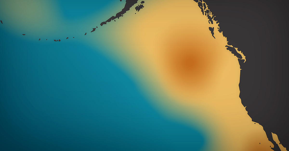
According to Earth Observatory, an unusually strong and persistent ridge of atmospheric high pressure emerged in the northeastern Pacific Ocean in 2013/14 – they named it the “Ridiculously Resilient Ridge” (RRR).
This unusual ridge shutdown winds which stopped ocean upwelling, so no deep, cool water up came to the surface, which led to unusually warm surface water in that area of the pacific ocean – which they named “The Blob”.
The RRR was at least partially to blame for California seeing 3 drought winters in a row. That high pressure ridge sat and high-pressure from coming into the CA for 3 years! Bastard!
NOAA thinks that the current strong El Nino has helped murder “The Ridiculously Resilient Ridge” & “The Blob”.
“Thanks in part to the strong El Niño in the equatorial Pacific, the Blob has finally broken up. Beginning in November 2015, strong winds blowing south from Alaska began to pick up, and sea surface temperatures in the northeastern Pacific began to cool.” – NOAA
Phytoplankton, fish and other marine life in that area thrive in cool water and this increased surface water temperature prompted them to avoid the area. The lack of bait fish influenced predator fish to avoid the area and led to starving sea lions and fur seals washing up on California coast line. The blob has recently disbanded, but the affects of it are still being felt!
![]()
Original Article:
In the winter of 2013-14, an unusually strong and persistent ridge of atmospheric high pressure emerged in weather maps of the northeastern Pacific Ocean. The feature, which was so unrelenting that meteorologists took to calling it the Ridiculously Resilient Ridge, weakened winds in the area enough that the normal wind-driven churning of the sea eased. Those winds usually promote upwelling, which brings deep, cool water up toward the surface; instead, the resilient ridge shut down the ocean circulation, leaving a large lens of unusually warm surface water in the northeastern Pacific.
At times, this patch of warm water seeped into the Bering Sea, the Gulf of Alaska, and the coastal waters off Washington, Oregon, and California. In fact, many parts of the northeastern Pacific experienced the greatest sea surface temperature anomalies in the historical record. Scientists and journalists took to calling the patch of warm water “the Blob.” Nicholas Bond, a University of Washington meteorologist and the Washington state’s climatologist, coined the term in a June 2014 newsletter.
As unusually warm surface water sloshed around for months, the grim consequences began to ricochet through the marine food web. Microscopic phytoplankton thrive in cool waters, so the lack of upwelling water meant surface waters became increasingly starved of nutrients. With fewer phytoplankton, fish and other marine life began to suffer. Certain types of fish started avoiding the region altogether, and by 2015 record numbers of starving sea lions and fur seals were found stranded on California’s beaches. Meanwhile, the warm water also began to produce some strange weather in the western United States.
Thanks in part to the strong El Niño in the equatorial Pacific, the Blob has finally broken up. Beginning in November 2015, strong winds blowing south from Alaska began to pick up, and sea surface temperatures in the northeastern Pacific began to cool.
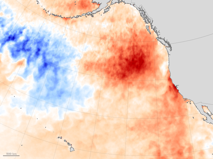
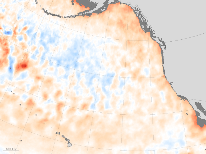
Data collected by the U.S. Navy’s WindSAT instrument on the Coriolis satellite and the AMSR2 instrument on Japan’s GCOM-W satellite bear this out. The maps above show sea surface temperature anomalies in the Pacific in July 2015 (top) and January 2016 (bottom). The maps do not depict absolute temperatures; instead, they show how much above (red) or below (blue) water temperatures were compared to the average from 2003 to 2012. The maps were built with data from the Microwave Optimally Interpolated SST product, a NASA-supported effort at Remote Sensing Systems.
In July 2015, temperatures were unusually warm across a large swath from the Gulf of Alaska to the California coast. By January 2016, more seasonable temperatures had returned. The development came as no surprise to weather watchers. In September 2015, Clifford Mass, a University of Washington atmospheric scientist, explained in his blog that El Niño generally brings lower-than-normal sea surface pressures to the eastern Pacific—the opposite of the systems that sustained the blob. By mid-December 2015, Mass declared that the blob was dead.
Remnants of the warm water patch still persist. “There are significant temperature anomalies extending down to a depth of about 300 meters. So while the weather patterns the past few months have not been that favorable to warming, it will take a while for all of the accumulated heat to go away,” explained Bond. That means impacts on marine life and on weather in the Pacific Northwest could linger, though Bond does not think the blob will return in the near term.
Article Link: http://earthobservatory.nasa.gov/IOTD/view.php?id=87513&eocn=image&eoci=moreiotd
You guys rock