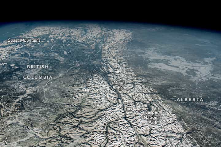
While orbiting western Montana, an astronaut aboard the International Space Station captured this photograph of the northern Rocky Mountains, also known as the Canadian Rockies. The Rockies are North America’s largest mountain range, sprawling approximately 4,800 kilometers (3,000 miles) long and nearly 650 kilometers (400 miles) wide at certain points. The Rocky Mountains extend from British Columbia, Canada, southeast toward New Mexico, in the United States.
At least 100 separate ranges comprise the Rockies, and they are separated into four geologic subdivisions: the Canadian and Northern Rockies, Middle Rockies, the Southern Rockies, and the Colorado Plateau. This image features the greater portion of the Canadian Rockies, which extends through northern British Columbia and southwestern Alberta. While there are approximately 50 peaks in the Canadian Rockies surpassing 3,350 meters (11,000 feet) in elevation, Mount Robson—in the center of the photo—is the highest peak at about 3,950 meters (12,970 feet) tall.
Jasper National Park, in Alberta, encompasses around 11,214 square kilometers (4,330 square miles) of mountainous terrain, glaciers, forests, and alpine landscapes. The park was established in 1907 and is one of several contiguous parks in the Canadian Rockies that have been recognized as a UNESCO World Heritage Site. The park also supports a vast diversity of wildlife. There are 53 different types of mammals found in the park, including bears (black and grizzly), wolves, elk, and cougars.
Part of the Coast Mountains, a major range along the Pacific coastline of British Columbia and Alaska, is visible in the upper-left part of the image. Glaciers carved out numerous valleys along the 1,600-kilometer (990-mile) long range, including several fjords along British Columbia’s Pacific coast.
This post first appeared on NASA Earth Observatory. Astronaut photograph ISS068-E-31571 was acquired on December 21, 2022, with a Nikon D5 digital camera using a focal length of 50 millimeters. It is provided by the ISS Crew Earth Observations Facility and the Earth Science and Remote Sensing Unit, Johnson Space Center. The image was taken by a member of the Expedition 68 crew. The image has been cropped and enhanced to improve contrast, and lens artifacts have been removed. The International Space Station Program supports the laboratory as part of the ISS National Lab to help astronauts take pictures of Earth that will be of the greatest value to scientists and the public, and to make those images freely available on the Internet. Additional images taken by astronauts and cosmonauts can be viewed at the NASA/JSC Gateway to Astronaut Photography of Earth. Caption by Minna Adel Rubio, GeoControl Systems, JETS Contract at NASA-JSC.