
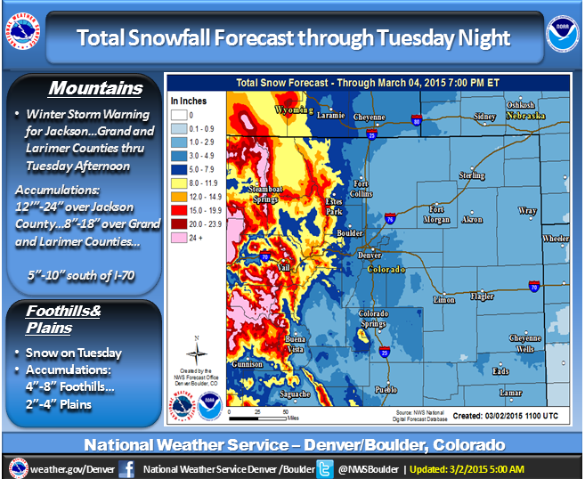
NOAA is forecasting a big storm for Colorado. 1-2 feet is expected. NOAA has issued a winter storm warning for much of Colorado for Monday and Tuesday.
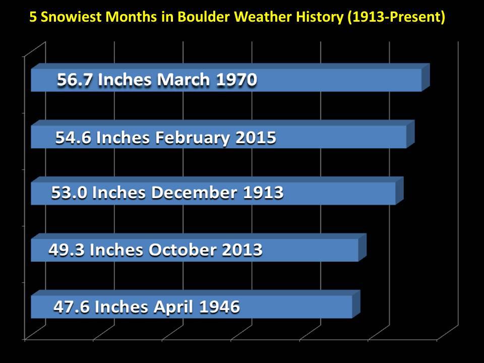
Boulder, CO just had its second snowiest month in recorded history:
NOAA’s Winter Storm Warning:
URGENT - WINTER WEATHER MESSAGE
NATIONAL WEATHER SERVICE GRAND JUNCTION CO
458 AM MST MON MAR 2 2015

...WINTER STORM WARNING REMAINS IN EFFECT UNTIL 5 PM MST TUESDAY
ABOVE 7000 FEET...

* LOCATIONS INCLUDE THE CITIES OF...ASPEN...VAIL...RIDGWAY.

* TIMING...HEAVY SNOW IS EXPECTED THIS EVENING AND WILL CONTINUE
  THROUGH TUESDAY.

* SNOW ACCUMULATION...1 TO 2 FEET THROUGH TUESDAY AFTERNOON.

* WINDS...SOUTHWEST 15 TO 25 MPH WITH GUSTS UP TO 40 MPH THIS
  AFTERNOON AND EVENING.

* VISIBILITY...RESTRICTED AT TIMES IN SNOW AND BLOWING SNOW.

* IMPACTS...TRAVEL IS EXPECTED TO BECOME DIFFICULT OR IMPOSSIBLE
  THROUGH WEDNESDAY.
NOAA Grand Junction, CO:
Today appears to be a transition day from the warm, moist phase of this strong long duration storm to the cold phase. As the closed low pressure system continues to dive down the California coast, pulling up sufficient moisture from the Pacific, a strong cold front and upper level jet will move across the area today. Southwest flow will strengthen out ahead of this front, bringing very windy conditions to much of the area. Winds are expected to range from 40 to 50 mph in the mountains with 15 to 30 mph seen in many valleys, with some locally higher gusts. This will result in blowing snow in the mountains and some valleys that see snow today. However, the southern and central lower valleys will still remain quite warm with mainly rain, possibly mixing in with some snow, limiting snow accumulations. The mountains, however, still stand to pick up an additional 1 to 2 feet from today through Tuesday night/Wednesday morning as snow continues to fall and pick up in intensity, with the heaviest this evening through Tuesday. The cold front will approach southeast Utah by 1 pm and move through the Grand Junction and western Colorado areas by 5 pm. This front will be quick to move through as we approach sunset and be through Vail Pass and the divide mountains by 7 pm. Much colder air will usher in behind, bringing in the second phase of this storm with snow favoring the northern valleys and northwest facing slopes of the mountains. Drier air moves in by Wednesday with most showers coming to an end and temperatures warming up as we work towards the weekend. – NOAA Grand Junction, CO on March 2nd, 2015