NOAA: Round 2 for California Tonight | 12-24″ of Snow of Snow By Monday Morning

WeatherBrains | | Post Tag for WeatherWeather
"Storm #1 is exiting the region, but Storm #2 will quickly follow on its heels. The biggest impact with Storm #2 will be over the mountains, as very high snowfall rates, much lower snow levels, and gusty winds will likely cause dangerous travel conditions. The Valley and foothill locations will likely see less rain than Storm #1 brought, but creeks and streams are still running high and localized flooding will still be possible. Gusty winds won't be quite as strong as on Saturday, but could still cause localized power outages." - NOAA Reno, NV today
“Storm #1 is exiting the region, but Storm #2 will quickly follow on its heels. The biggest impact with Storm #2 will be over the mountains, as very high snowfall rates, much lower snow levels, and gusty winds will likely cause dangerous travel conditions. The Valley and foothill locations will likely see less rain than Storm #1 brought, but creeks and streams are still running high and localized flooding will still be possible. Gusty winds won’t be quite as strong as on Saturday, but could still cause localized power outages.” – NOAA Reno, NV today

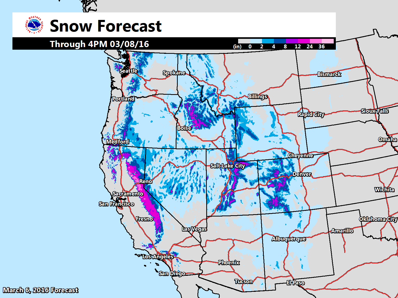
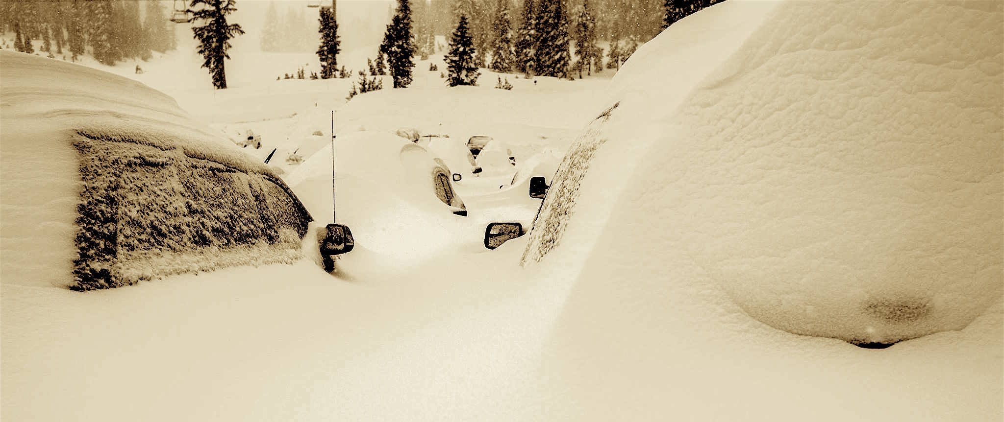
California ski resorts just got buried in up to 56″ of new snow the past two days.  

NOAA has issued Winter Storm Warnings from the southern Cascade mountains deep in NorCal all the way down to the Mexican border.

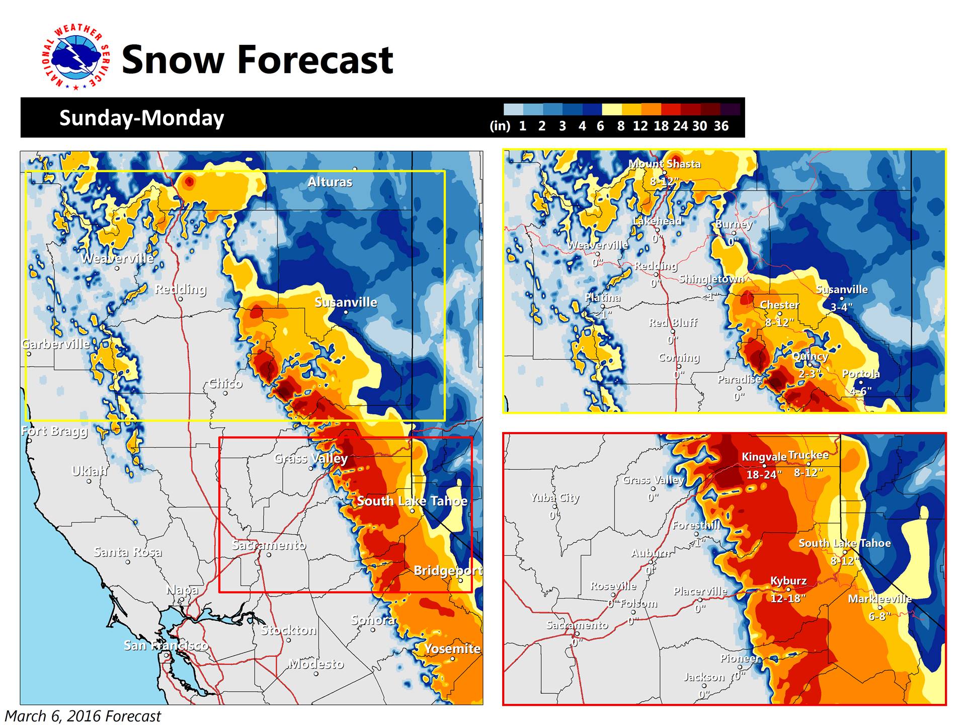
By Monday morning NOAA is forecasting:

  • 1-2 feet of snow in NorCal above 7,000-feet by Monday morning.  
  • 1-2″ per hour snowfall rates
  • Wind gusts up to 100mph
  • 2-4 foot waves on Lake Tahoe
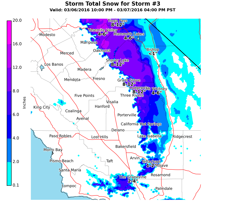
  • 4-10″ of snow forecast for the Mexican border…
* ADDITIONAL SNOW ACCUMULATIONS: 1 TO 2 FEET ABOVE 7000 FEET WITH
  6 TO 12 INCHES BETWEEN 6000 AND 7000 FEET...INCLUDING LAKE TAHOE
  AND IN MONO COUNTY ALONG AND WEST OF HIGHWAY 395. EAST OF
  HIGHWAY 395...3 TO 6 INCHES. - NOAA Reno, NV today
"Our next system will move in this evening bringing very heavy snow above 4000 ft! Expect chain controls and avoid travel over the mountains if possible." - NOAA Sacramento, CA today
“Our next system will move in this evening bringing very heavy snow above 4000 ft! Expect chain controls and avoid travel over the mountains if possible.” – NOAA Sacramento, CA today

Winds are forecast to gust as high as 100mph and Lake Tahoe is forecast to see 2-4 foot waves.  Surfs up!

* WINDS: SOUTHWEST 15 TO 30 MPH WITH GUSTS UP TO 45 MPH. SIERRA
  RIDGE GUSTS UP TO 100 MPH.

* LAKE TAHOE CONDITIONS: WAVE HEIGHTS 2 TO 4 FEET. - NOAA Reno, NV today
"This evening, another system will move in bringing more rain/wind. Winds will be weaker than our previous storm although still quite strong. 1-2 ft. of snow above 4000ft!" - NOAA Sacramento, CA today
“This evening, another system will move in bringing more rain/wind. Winds will be weaker than our previous storm although still quite strong. 1-2 ft. of snow above 4000ft!” – NOAA Sacramento, CA today

CA has seen huge snowfalls the past 2 days.

CALIFORNIA 2-DAY SNOWFALL TOTALS:

  • Mammoth = 56″
  • Dodge Ridge = 34″
  • Kirkwood = 30″
  • Sierra at Tahoe = 30″
  • Squaw Valley = 28″
  • Sugar Bowl = 26″
  • Northstar = 26″
  • Alpine Meadows = 21″
  • Bear Valley = 21″
  • Mt. Rose, NV = 18″
  • Heavenly = 16″
  • Diamond Peak, NV = 10″
PINK = Winter Storm Warning. PURPLE = WInter Weather Advisory. image: noaa, today

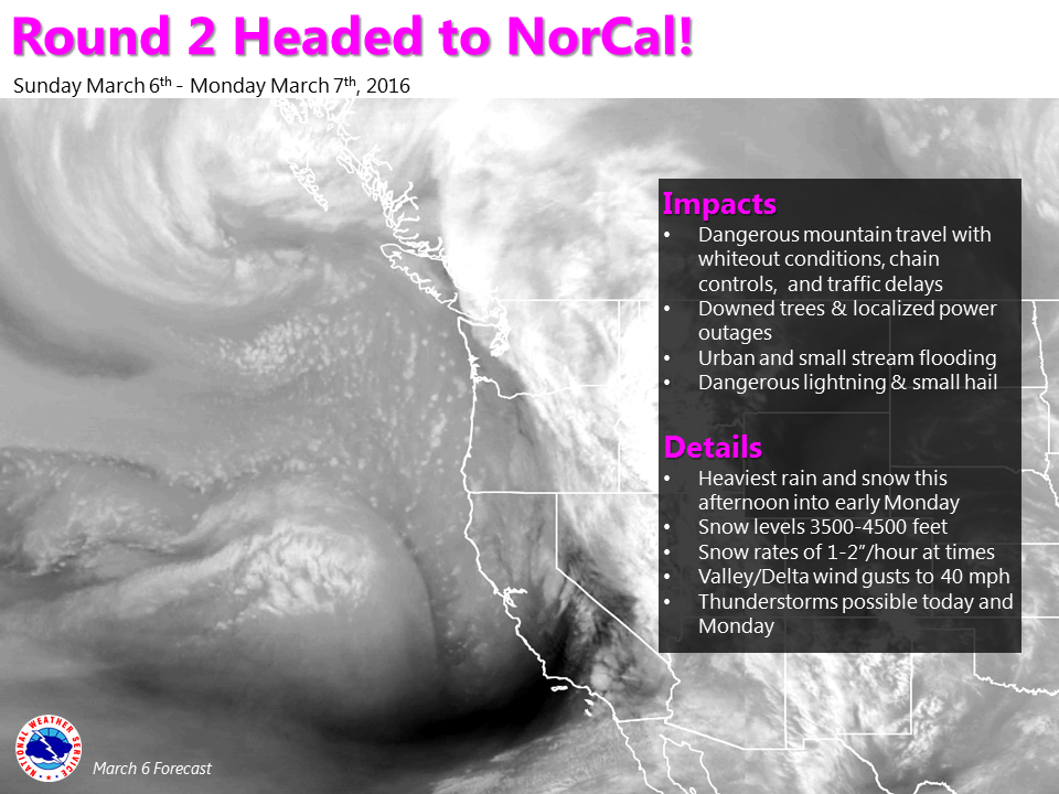
WINTER STORM WARNING for CALIFORNIA:

URGENT - WINTER WEATHER MESSAGE
NATIONAL WEATHER SERVICE RENO NV
1035 AM PST SUN MAR 6 2016

GREATER LAKE TAHOE AREA-MONO COUNTY-
INCLUDING THE CITIES OF...SOUTH LAKE TAHOE...TRUCKEE...
BRIDGEPORT...MAMMOTH LAKES...INCLINE VILLAGE

...WINTER STORM WARNING REMAINS IN EFFECT UNTIL 10 AM PST
MONDAY...

* TIMING: SNOW WILL INCREASE AGAIN THIS EVENING WITH ANOTHER
  ROUND OF HEAVY SNOW LIKELY LATER TONIGHT INTO MONDAY MORNING.

* ADDITIONAL SNOW ACCUMULATIONS: 1 TO 2 FEET ABOVE 7000 FEET WITH
  6 TO 12 INCHES BETWEEN 6000 AND 7000 FEET...INCLUDING LAKE TAHOE
  AND IN MONO COUNTY ALONG AND WEST OF HIGHWAY 395. EAST OF
  HIGHWAY 395...3 TO 6 INCHES.

* WINDS: SOUTHWEST 15 TO 30 MPH WITH GUSTS UP TO 45 MPH. SIERRA
  RIDGE GUSTS UP TO 100 MPH.

* LAKE TAHOE CONDITIONS: WAVE HEIGHTS 2 TO 4 FEET. CONSIDER
  POSTPONING BOATING ACTIVITY UNTIL A DAY WITH LESS WIND.

* IMPACTS: LONG DELAYS AND CHAIN CONTROLS ARE LIKELY. THE
  COMBINATION OF WIND AND SNOW MAY CREATE PERIODS OF NEAR ZERO
  VISIBILITY.
"Well, here it is...the forecast precipitation and snowfall for Storm #3. Images are valid tonight through Monday." - NOAA Hanford, CA today
“Well, here it is…the forecast precipitation and snowfall for Storm #3. Images are valid tonight through Monday.” – NOAA Hanford, CA today
"Periods of heavy snow mountain snow over the next several days across portions of the western U.S. Use caution if you will be traveling in these areas!" - NOAA, today
“Periods of heavy snow mountain snow over the next several days across portions of the western U.S. Use caution if you will be traveling in these areas!” – NOAA, today
10296314_10152949567962395_6176838122975998773_o 2
Mammoth, CA today. photo: mammoth
100mph wind gusts at Squaw last night. Gusts in the 60s and 70s today.
Sugar Bowl
Sugar Bowl
Mammoth
Mammoth

Related Articles

Got an opinion? Let us know...