October will be here next week, the month when the snow starts to fall and accumulate, and the first ski resorts begin to open. How much snow falls and how early resorts open though is dependent on the weather.
It’s looking good for the PNW, with normal temperatures and above-normal precipitation expected. The rest of the country can expect above-normal temperatures, with the east coast also likely to see above-normal precipitation.
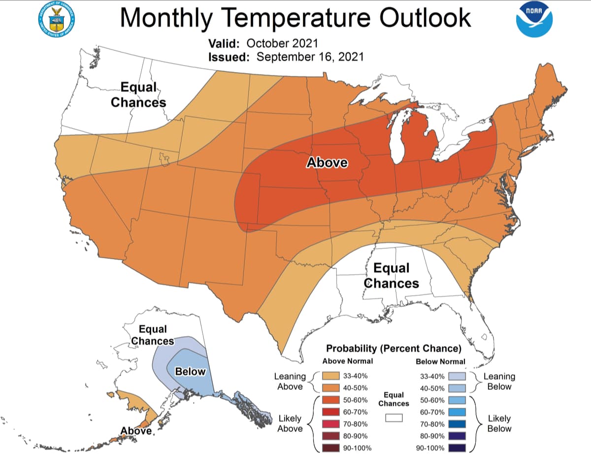
Here’s the NOAA’s outlook for October:
The October 2021 outlook is prepared with a backdrop of most likely developing La Nina conditions in the equatorial Pacific Ocean both in the ocean and atmosphere. The MJO, although not as coherent and well defined as during the months of July and August remains a factor in the outlook as does antecedent soil moisture conditions and coastal sea surface temperature anomalies.Statistical, hybrid, and dynamical model-based forecast guidance contribute significantly to the October outlook.
For temperature, the outlook depicts favored above-normal monthly mean Octobertemperatures for much of the contiguous U.S. with the region stretching from the Southwest eastward to cover the Great Plains and extending across the Ohio Valley, Great Lakes, mid-Atlantic and Northeast. The greatest odds are generally in the center of this highlighted region for a variety of factors such as antecedent surface moisture departures from normal, prospects for potential developing La Nina impacts as well as dynamical model forecast information. Although the eventual evolution of the MJO and so its impacts on the U.S. are uncertain given its current state, the MJO would favor above-normal temperatures for much of the central and eastern contiguous U.S. during the first two weeks of October.
Favored unsettled conditions and associated enhanced cloudiness and rainfall increase uncertainty near the Gulf Coast and so Equal-Chances (EC) is depicted in this region as well as in the Pacific Northwest where conflicting signals in climate forecast tools and information are present.
Favored troughing to the north of Alaska and anomalous north to south meridional flow supports elevated odds for below-normal temperatures for portions of interior and southeast Alaska and the Alaska Panhandle. This is supported by much of the available dynamical model guidance as well as potential impacts from developing La Nina conditions over the next six weeks. Above-normal sea surface temperatures in nearby coastal waters for the Aleutians and southwest Alaska as well as some dynamical model guidance support modest odds for above-normal temperatures for southwest Alaska and the Aleutians.
The October precipitation outlook is influenced by potential background La Nina and MJO impacts in some areas as well as both statistical forecast tools and dynamical model guidance. Elevated odds for below-normal October total precipitation amounts is depicted for a region from California eastward to include the Southwest, the central Rockies and the central and southern Great Plains — based on potential La Nina impacts and support from much of the dynamical model guidance.
The most consistent signal in the forecast tools is for elevated probabilities for above-normal precipitation for the Pacific Northwest as depicted by model guidance and consistent with La Nina impacts for this time of the year. This signal extends northward to include the Alaska Panhandle. Anticipated anomalous north to south meridional flow supports and is the basis for a small, generally weak tilt in the odds for below-normal precipitation for the south-central portion of the state.
Across the eastern CONUS, a region of elevated odds for above-normal precipitation is depicted from the Gulf coast, eastern seaboard and for parts of the Great Lakes and Northeast. The southern areas of this highlighted area are primarily based on potential tropical cyclone related impacts linked to the climatological secondary peak in tropical cyclone activity in October for areas in the northwest Caribbean Sea and Gulf of Mexico. In addition, a potential factor later in the month could be the MJO influence of above-normal precipitation in this region linked to MJO RMM phase 8 through 2. The forecast in this area is at odds for much of the dynamical model guidance where near- to below-normal monthly precipitation amounts are forecast, thus there is considerable uncertainty in the forecast in this area.
The forecast for above-normal precipitation further north in the mid-Atlantic, much of the Great Lakes and Northeast is primarily related to long term positive precipitation trends and supplemented by signals from some of the dynamical model forecast output.
