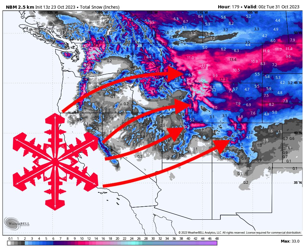
The largest winter storm of the season thus far is forecasted to dig into the Western US this week, bringing major snowfall to Utah, Colorado, Wyoming, and Montana. There will be widespread 6+ inch totals with local maxima in southern Montana and northern Wyoming exceeding 2-3+ FEET. This storm will provide a much-needed boost for resorts looking to open in the next few weeks and will usher in a cold airmass that will bring around-the-clock snowmaking conditions.
This storm will also bring major snow to the Pacific Northwest, which we covered in its own forecast earlier this morning.
Montana and Wyoming will see light showers on Monday, bringing a few inches to upper elevations but not much accumulation beyond that. Significant precipitation will fill into central Montana on Tuesday afternoon and evening, intensifying and inching south into Wyoming by Wednesday morning.
On Thursday morning, the band of snowfall will reach northern Utah. On Thursday morning, Montana, Wyoming, and Utah will dry out, while Colorado will see showers in the northern and western mountains.
Beyond this, there is fairly poor model agreement, but the general consensus is increasingly shifting towards some more excitement firing up over Utah on Friday afternoon/evening and spreading into Wyoming and Colorado overnight. This additional storm energy should linger in Utah until Sunday evening, and could linger in Colorado into Monday and Tuesday.
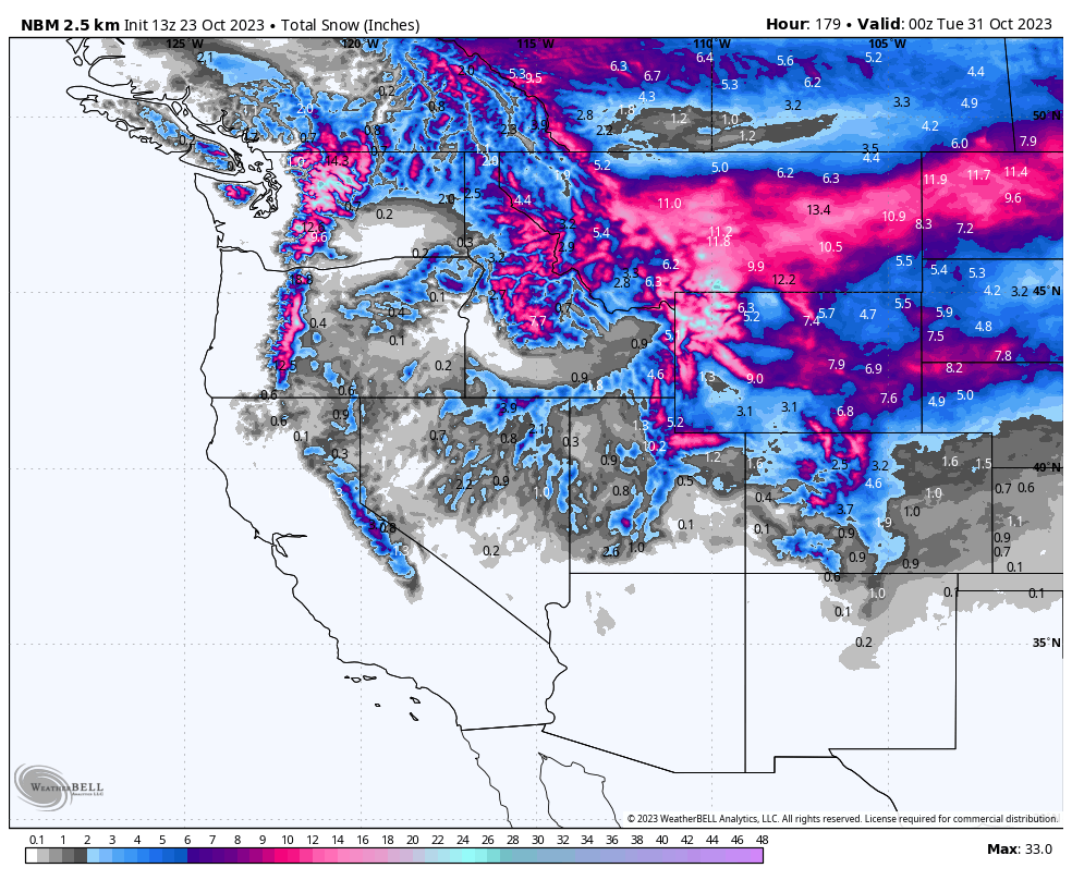
Let’s take a look at regional totals. I try to capture a realistic range, however these forecasts are on the conservative side, so reported totals may exceed the forecast. Better for a forecast to bust low than bust high!
Montana
Montana will be located under the jet stream for much of the storm, which will bring intense, fairly non terrain-dependent snowfall to much of the state; even lower terrain should see quite impressive totals. However, the deepest snowfall totals will likely be found in southern Montana, right near the MT/WY border. The highest elevations in this region will likely see totals exceeding 3 feet. Of all the resorts in the region, Big Sky will likely be the winner, with 12-18″ likely by the end of the weekend.
Wyoming
Wyoming will also get hammered, with major accumulations in the Yellowstone area, Tetons, Wind Rivers, and Bighorns. The Tetons will likely see the most accumulation, with 6-15″ possible at Jackson Hole. Jackson’s summit will likely be in the 12-20″ range.
Utah
This is a tough storm to forecast for this region, since the final totals will depend heavily on how much that secondary surge of storm energy materializes on Friday afternoon into the weekend. The first push should bring 10-16″ to Cottonwood resorts. The second, on Friday and into the weekend, should bring several more inches, but whether that’s 1 inch or 6 inches remains to be seen.
Colorado
The Colorado forecast for this storm is another tricky one. What we do know is that northern and western Colorado receive the most snow. Southern Colorado, mainly the San Juans, will still see some snowfall, but likely only a few inches. By Monday, we’re probably looking at 6-12″ at Steamboat, 4-10″ for Summit County resorts, and 3-8″ for the central mountains (Vail, Snowmass, Crested Butte, etc).
Looking ahead
Looking ahead, cold air brought in by this storm will hang around for some time, likely into late next week. The next opportunity for snowfall in the West will be late next week into the weekend. Stay tuned for an updated forecast next week!