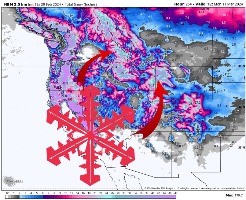
Busy upcoming week across the west. Source: maps.weatherbell.com
This forecast was prepared at 5 pm PT on Thursday, February 29, 2024
It’s no secret that the Northern Rockies have been lagging behind this season regarding snowpack. While last week’s storm certainly helped, a very active first week of March may be just what the doctor ordered.
Short-term Forecast (Now-SAT)
The Northern Rockies will be influenced by two separate low-pressure systems over the next few days, each with an associated cold front bringing significant snowfall. The first low-pressure system moves W-E across the US/Canada border tonight, bringing colder air and a swath of snow from Canada down through Southern Idaho.
The second low-pressure system moves further south, bringing colder air and another batch of snow on Saturday.
The first trough merges with the second, deeper trough. Source: maps.weatherbell.com
These storms may be particularly impactful for NW Wyoming because the first cold front looks to stall out Friday night over the Tetons/Wind Rivers before merging with the second cold front Saturday morning. If snowfall rates are even close to 1″/hr in the area of the cold front, which they are likely to be, this could produce at least 12″ of snow for the Jackson-area resorts during this time period alone.
The second cold front comes Saturday morning without any real break in snowfall. However, snowfall rates will noticeably increase as this front moves through, dropping several more inches of snow across the Northern Rockies through Saturday evening.
Estimated snowfall pattern. Source: maps.weatherbell.com
Estimated Snow Totals Through Saturday Night:
- Tamarack (ID): 14-22″
- Bogus Basin (ID): 6-14″
- Sun Valley (ID): 12-18″
- Big Sky (MT): 5-10″
- Bridger Bowl (MT): 4-10″
- Whitefish (MT): 6-12″
- Jackson Hole (WY): 16-26″
- Grand Targhee (WY): 18-30″
Long-term Forecast (SUN and Beyond)
Snow showers continue Sunday and Monday, producing further light snow accumulations for most resorts.
A more impactful day looks possible on Tuesday, as another low-pressure system in Southern Canada keeps the trough from entirely lifting and producing another weak cold front that could bring another organized band of snow somewhere in the Northern Rockies.
An active pattern seems likely to continue past Tuesday, as North America remains stuck in a pattern where systems repeatedly move down from Alaska, across the western coast of Canada, and ultimately target the Rockies.
The Euro showing another potential band across Idaho on Tuesday. Source: maps.weatherbell.com