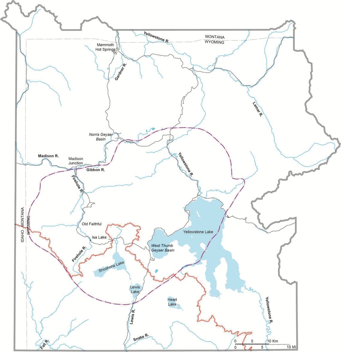
There are numerous hot springs and a lot of water flowing in Yellowstone, but what is the fate of the hot water erupted from Old Faithful Geyser, for example? Where does that water ultimately end up?
The journey begins when the thermal water gushes from Old Faithful into the nearby Firehole River, which drains all the water flowing out of hot springs and geysers in Yellowstone’s Upper, Midway (where the iconic Grand Prismatic Spring is located) and Lower Geyser Basins. At Madison Junction, the Firehole River merges with the Gibbon River carrying water from Norris Geyser Basin, to form the Madison River. The Madison River, at this point, accounts for nearly half of the hot spring water discharged from the entire park, as indicated by the amount of chloride measured in the rivers.
The Madison River crosses from Wyoming to Montana just north of the town of West Yellowstone, Montana, and then into the Hebgen Lake Reservoir, the site of a large (M 7.3) earthquake in 1959. From there, the river heads north to the confluence with the Jefferson and Gallatin rivers in Central Montana to form the Missouri River. The Yellowstone River, the largest watershed in Yellowstone National Park, also flows into the Missouri River in North Dakota after it has traversed much of Montana.
At more than 2,300 miles (3,700 km), the Missouri River is the longest river in North America. It cascades over several large falls before emptying into the Mississippi River north of St. Louis, Missouri. The journey along the Mississippi River from its confluence with the Missouri River to its mouth at the Gulf of Mexico is about 1,200 miles (about 1,900 kilometers) long. In total, some of the water that erupted from Old Faithful geyser traveled for more than 3,700 miles (almost 6,000 kilometers) before entering the Gulf of Mexico. This is more than 1,000 miles longer than the flight distance between New York and Los Angeles.
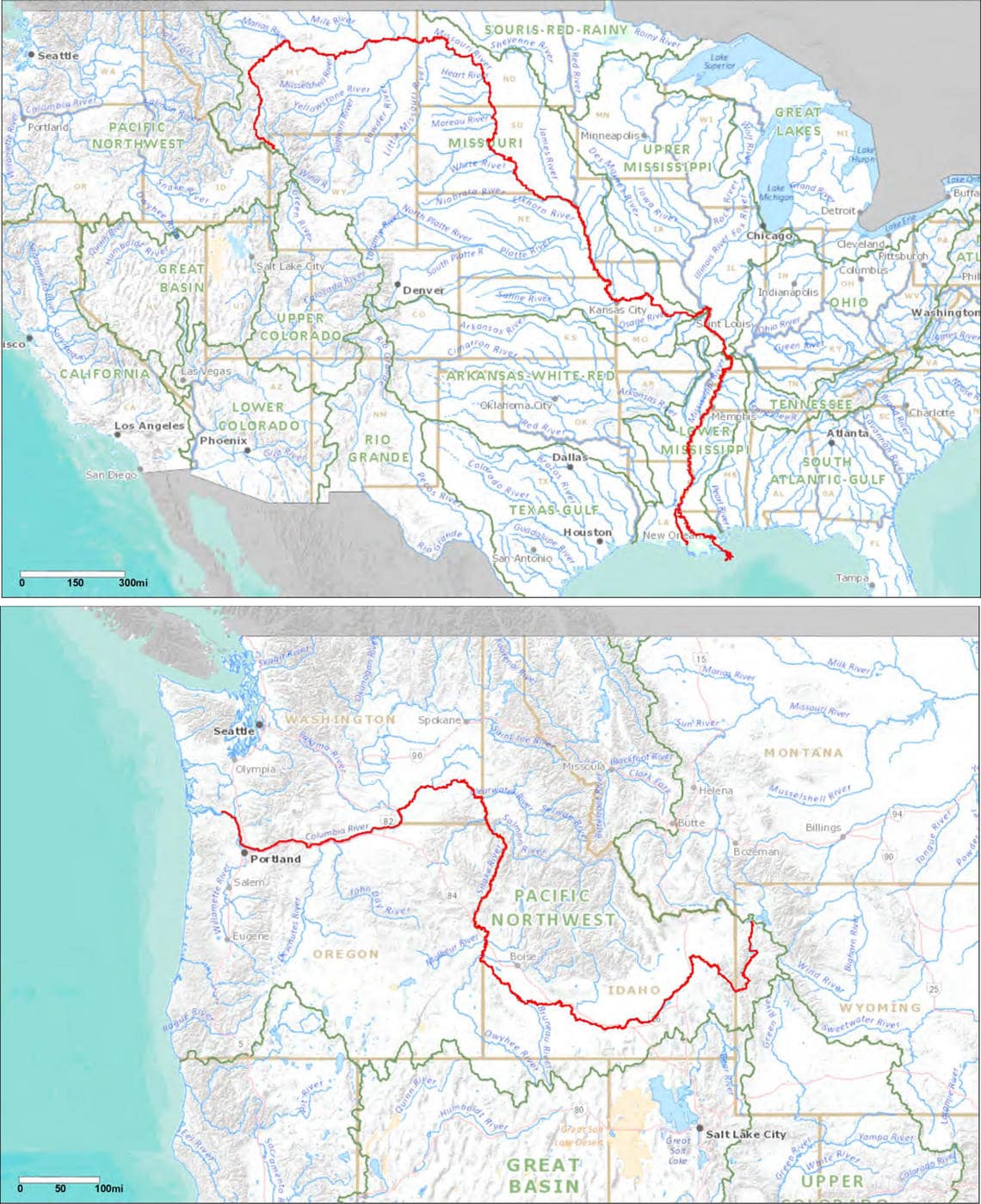
But what is the path of water flowing out of hot springs near the shores of Shoshone, Lewis, and Heart Lakes, all located in the Southern part of Yellowstone, to the ocean? After trickling into Shoshone Lake, water from the hot springs along its western shore flows down the Upper Lewis River, which begins at the southern end of Shoshone Lake and pours into Lewis Lake. The Lewis River reemerges at the southern end of Lewis Lake and cascades through a steep canyon with several waterfalls into the Snake River near the southern boundary of Yellowstone National Park. The Snake River begins in southwest Yellowstone, then streams southwest into Grand Teton National Park, southern Idaho, the Oregon–Idaho border, and finally into the Columbia River in southeastern Washington after nearly 1,100 miles (1,750 km). The Columbia River, which is the largest North American river that flows into the Pacific Ocean, flows for more than 300 miles (500 km) before entering the ocean on the Oregon-Washington border. In all, water from hot springs near the shores of Shoshone and Heart Lakes traverses about 1,400 miles (2,250 kilometers) before entering the Pacific Ocean.
Why does the water that erupts from Old Faithful Geyser flow all the way to the Gulf of Mexico whereas water from the hot springs on the shores of Shoshone Lake end up in the Pacific Ocean? The continental divide, which runs for about 115 miles (185 kilometers) through much of southern Yellowstone National Park, forms a barrier that separates one drainage basin from another. Water coursing north and east of the continental divide will flow out of the park through the Madison, Gardner, or Yellowstone Rivers and eventually to the Gulf of Mexico. Water streaming south and west of the divide will flow out of the park through the Snake and Fall Rivers and eventually to the Pacific Ocean.
The presence of the Continental Divide in the park can make for some curious features. Isa Lake is located directly astride the Continental Divide at Craig Pass along the road that connects Old Faithful and West Thumb Geyser Basin on the shore of Yellowstone Lake. Isa Lake is one of the few natural lakes in the world which drains to two different oceans. The east side of Isa Lake drains into the Lewis River and after a very long journey, into the Pacific Ocean. The west side of the lake drains into the Firehole River and ultimately to the Gulf of Mexico.
So, the next time you happen to see Old Faithful Geyser erupting, take a moment to appreciate the long journey that the water is beginning. The waters of Yellowstone go on spectacular trips, ending in both oceans and traversing thousands of miles along the way!
This post first appeared on USGS and was written by Shaul Hurwitz.
This is neat