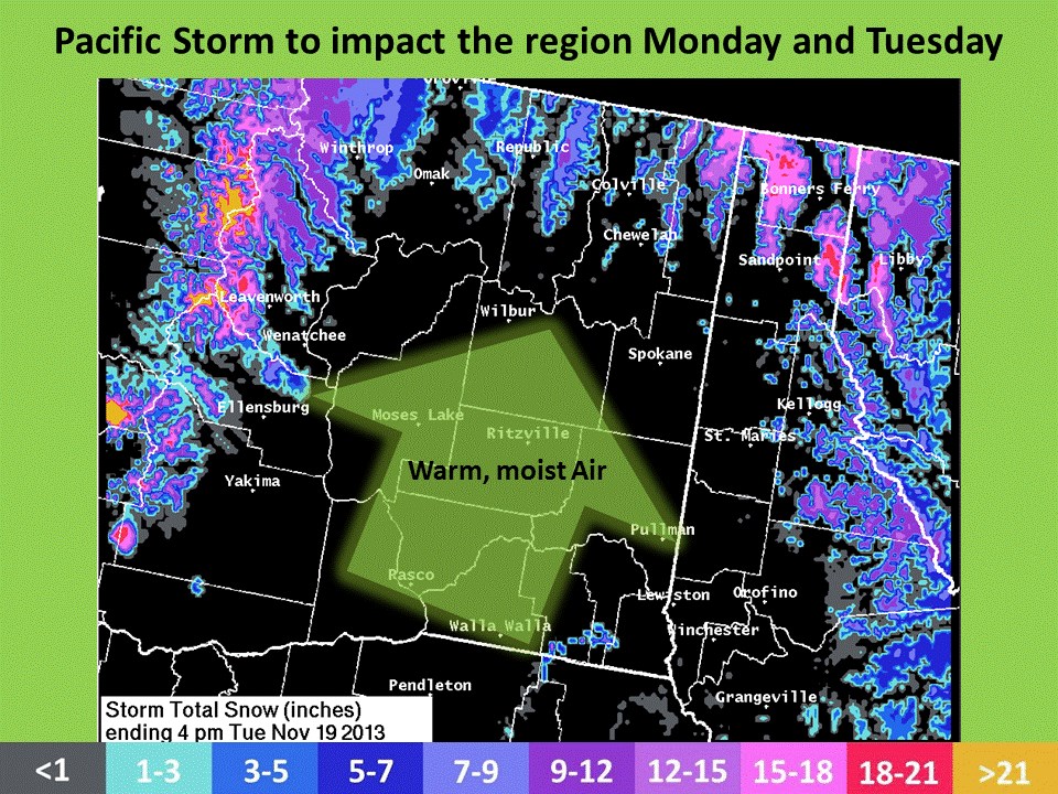
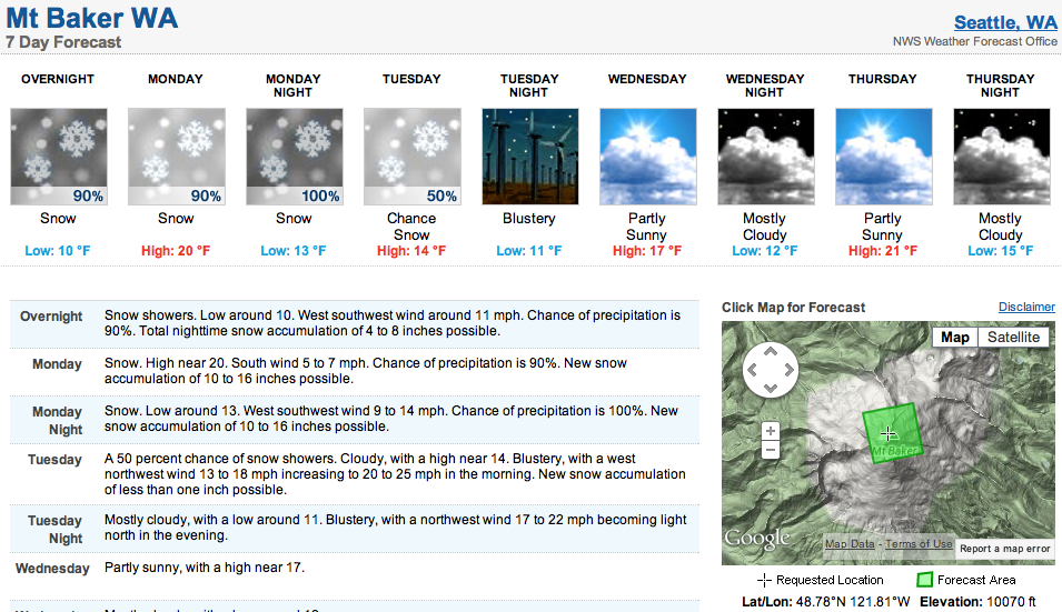
As of last night, Mt. Baker, WA was forecasted to receive 40 inches of new snow Sunday night and Monday. The above map, issued by NOAA, shows that the highest elevation locations in Washington’s cascades are forecasted to get over 21 inches of new snow through Tuesday. The only problem with this storm is that snow levels start low, around 2,500’ today before rising on tonight to near 6,000’.
Washington has been getting nailed this fall and there is no end in sight. In the end of September, 10,781-foot Mt. Baker got 13 feet in 4 days and in the past 2 weeks there have been two separate incidents where Mt. Baker got over 50” in 4 days.
Mt. Baker ski resort has begun grooming trails and packing down snow as they prepare to open soon. Maybe this week? We hope so.
NOAA:
“Moist, southwest flow will increase Monday ahead of a strong warm front transporting a fetch of subtropical moisture into the region. Precipitation will develop across the Cascades and northern mountains early Monday then spread into the Basin Monday afternoon. The mild air mass will bring rain in the valleys and snow…heavy at times in the mountains. The one exception will be the northern valleys tucked in the East Slopes of the WA Cascades including the Methow Valley where colder air will be slower to scrub out. Snow levels will start off between 2500-4000’ then increase between 5000-6000 ft Monday night. Tuesday, a strong cold front will cross the region delivering cooler and drier air. Main impacts from this storm will be heavy mountain snow, gusty winds in the Basin, and potential for rises in creeks and streams as snow levels climb and precipitation intensity increases Monday night. This image represents snow totals for Monday and Tuesday ending 4pm.” – NOAA
WINTER WEATHER ADVISORY:
URGENT - WINTER WEATHER MESSAGE
NATIONAL WEATHER SERVICE SEATTLE WA
324 AM PST MON NOV 18 2013

...WINTER WEATHER ADVISORY IN EFFECT FROM 10 AM THIS MORNING TO
4 AM PST TUESDAY FOR ELEVATIONS ABOVE 4000 FEET...

* HAZARD TYPE...A PACIFIC FRONTAL SYSTEM WILL BRING 6 TO 14 INCHES
  OF SNOW TO THE CASCADES ABOVE 4000 FEET TODAY AND TONIGHT.
  PRECIPITATION AT ELEVATION 4000 FEET AND BELOW COULD START AS
  SNOW BUT IT WILL CHANGE TO RAIN...POSSIBLY HEAVY AT TIMES...THIS
  AFTERNOON OR EVENING.

* SOME AFFECTED LOCATIONS...THE HIGHER ELEVATION PORTIONS OF THE
  MOUNT BAKER HIGHWAY AND THE ROAD TO PARADISE AT MOUNT RAINIER
  WILL RECEIVE THE MOST SNOW FROM THIS STORM. THE CASCADE HIGHWAY
  PASSES INCLUDING STEVENS...SNOQUALMIE...AND WHITE PASS WILL
  LIKELY RECEIVE LESS THAN 6 INCHES OF SNOW...BUT RAINFALL THERE
  COULD BE HEAVY AT TIMES THIS AFTERNOON AND EVENING.

* TIMING...PRECIPITATION WILL INCREASE THIS MORNING...BE HEAVIEST
  DURING THE AFTERNOON AND EVENING...THEN DECREASE LATER TONIGHT.
RELATED POSTS:
Mt. Baker, WA Conditions Report Video: 20” of New Snow & Face-Shots on November 15th
Just a touch too warm for the ski resort. bc could be good though
Stop posting snowfall for the top of Mt Baker. Thats like using Shasta or Lassen during a rain event in Tahoe.