
This year has been historic for Yellowstone National Park in more ways than one. Founded in 1872, America’s first national park is celebrating its 150th anniversary. It also experienced historic flooding, with rivers cresting at heights not seen in 100 years.
In the second week of June 2022, an atmospheric river—a narrow band of tropical moisture—soaked the Pacific Northwest before dumping several inches of rain on northern Wyoming and southern Montana. The inundation coincided with a warm spell that exacerbated melting of the heavy snowpack.
“This led to flooding rarely or never seen before across many area rivers and streams,” according to the National Weather Service (NWS) in Billings, Montana.
On June 13, park officials closed Yellowstone—which spans 2.2 million acres (8,900 square kilometers) in northwest Wyoming, southwest Montana, and eastern Idaho—and announced the evacuation of more than 10,000 visitors due to safety concerns. Campsites were flooded, roads were washed out, and rocks tumbled onto roadways.
Despite a slow start to the 2021–2022 water year, a cool, wet spring brought much-needed water to the region, which has been experiencing drought conditions. In April, higher than median precipitation in the Yellowstone basin helped build up the snowpack on the ground, which had increased to nearly the 30-year median by May. The Moderate Resolution Imaging Spectroradiometer (MODIS) on NASA’s Terra satellite captured these images comparing snowpack on June 16, 2022, to the snowpack on the same date in 2021.
Between June 10 and 13, the Absaroka and Beartooth ranges received between 0.8 and 5 inches of rain, which combined with 2 to nearly 5 inches of snowmelt, according to the Billings NWS. The combined rain and snowmelt, equivalent to 4 to 9 inches (10 to 22 centimeters) of rain, flowed over already damp soils.
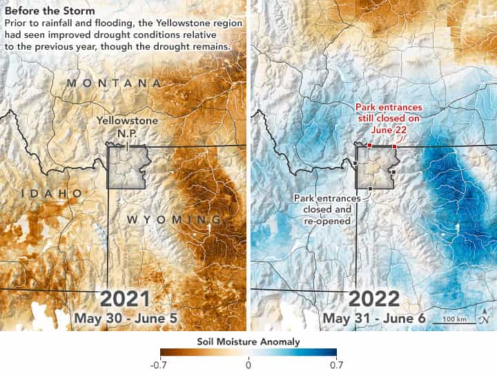
The maps above show the soil moisture anomaly in northern Wyoming and southern Montana during the week before the storm. The maps were built with data from the Crop Condition and Soil Moisture Analytics (Crop-CASMA) product. Crop-CASMA integrates measurements from NASA’s Soil Moisture Active Passive (SMAP) satellite and vegetation indices from the MODIS instruments on NASA’s Terra and Aqua satellites. The left map shows soil moisture conditions between May 30 and June 5, 2021, when the state was experiencing more severe drought conditions. The image at right shows soil moisture conditions from May 31 to June 6, 2022, just before the rainfall.
The runoff deluged the Yellowstone, Stillwater, and Clarks Fork rivers and their tributaries. At Corwin Springs, north of Gardiner, Montana, the Yellowstone River crested at 13.88 feet on June 13, 2022, breaking the previous record of 11.5 feet set on June 14, 1918. A record river discharge of 51,400 cubic feet per second was also measured that day, breaking the previous record-high flow of 32,200 cubic feet per second in 1996, according to U.S. Geological Survey stream gauges.
North of the park, Gardiner and Cooke City were isolated by the rising floodwaters, which washed-out roads and bridges, swept away multiple houses, and flooded hundreds more. Rock Creek took out several bridges and flooded businesses in the historic downtown of Red Lodge, Montana. The flooding also caused power outages and compromised drinking water supplies in several towns.
The northern part of the park, where the river flows through steep canyons, suffered the most damage as the Yellowstone River cut a new course. The road between Gardiner and the park headquarters near Mammoth Hot Springs, a main supply route into the park, was washed out and it is expected to take months to repair.
The southern part of the park saw less damage from the flooding. On June 22, 2022, the west, south, and east entrances were re-opened along with the southern loop road, giving visitors access to Old Faithful. The north and northeast entrances to the park are closed indefinitely.
This post first appeared on NASA Earth Observatory. NASA Earth Observatory images by Joshua Stevens, using soil moisture data from Crop Condition and Soil Moisture Analytics (Crop-CASMA) and MODIS data from NASA EOSDIS LANCE and GIBS/Worldview. Story by Sara E. Pratt.